IMAGES TAKEN NEAR TO
The Greenways, South Western Road, TWICKENHAM, TW1 1LH
Introduction
This page details the photographs taken nearby to The Greenways, South Western Road, TW1 1LH by members of the Geograph project.
The Geograph project started in 2005 with the aim of publishing, organising and preserving representative images for every square kilometre of Great Britain, Ireland and the Isle of Man.

There are currently over 7.5m images from over14,400 individuals and you can help contribute to the project by visiting https://www.geograph.org.uk
Image Map (Loading...)


Getting Data...Please wait
Leaflet Map data © OpenStreetMap
Images are licensed for reuse under creativecommons.org/licenses/by-sa/2.0
Notes
- Clicking on the map will re-center to the selected point.
- The higher the marker number, the further away the image location is from the centre of the postcode.
Image Listing (56 Images Found)
Images are licensed for reuse under creativecommons.org/licenses/by-sa/2.0
Image
Details
Distance
1
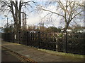
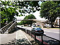
Moor Mead Bridge
Moor Mead Bridge takes Hill View Road over the River Crane. The tower blocks in the distance are on the Ivybridge Estate.
Image: © Marathon
Taken: 8 Dec 2010
0.04 miles
2
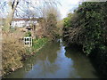
River Crane
River Crane from the Moor Mead Bridge on Hill View Road
Image: © Shaun Ferguson
Taken: 15 Feb 2013
0.05 miles
3
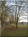
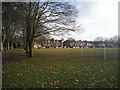
Moor Mead, Twickenham
This small open space between St Margarets and Twickenham stations is known as Moor Mead. Its trees are its most attractive feature as seen in this avenue alongside Hill View Road.
Image: © Marathon
Taken: 8 Dec 2010
0.06 miles
4
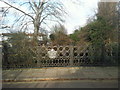
Moor Mead Bridge
The attractive Moor Mead Bridge carries Hill View Road across the River Crane. This view is looking downriver.
Image: © Marathon
Taken: 8 Dec 2010
0.06 miles
5
Moor Mead
This small open space between St Margarets and Twickenham stations is known as Moor Mead. Its trees are its most attractive feature. This view is looking from alongside Hill View Road towards Moor Mead Road.
Image: © Marathon
Taken: 8 Dec 2010
0.06 miles
6
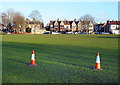
Cones in Cole Park
Or Moor Mead Ground. The name changes depending on which scale map you are looking at.
Image: © Des Blenkinsopp
Taken: 8 Jan 2019
0.08 miles
9
Bailey footbridge on A316 St Margaret's, Twickenham
The bridge, ramps and supports are made from Bailey Bridge panels by Thomas Storey (Engineering). It is used by pupils of St Stephen's Primary on the left of the picture. The ramps have intermediate steps.
Image: © pablo haworth
Taken: 25 Jun 2014
0.13 miles
10
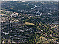
St Margarets from the air
The River Crane can be seen in the foreground.
Image: © Thomas Nugent
Taken: 19 Jun 2015
0.13 miles