IMAGES TAKEN NEAR TO
Pulsford Close, TWICKENHAM, TW1 1AY
Introduction
This page details the photographs taken nearby to Pulsford Close, TW1 1AY by members of the Geograph project.
The Geograph project started in 2005 with the aim of publishing, organising and preserving representative images for every square kilometre of Great Britain, Ireland and the Isle of Man.

There are currently over 7.5m images from over14,400 individuals and you can help contribute to the project by visiting https://www.geograph.org.uk
Image Map
Images are licensed for reuse under creativecommons.org/licenses/by-sa/2.0
Notes
- Clicking on the map will re-center to the selected point.
- The higher the marker number, the further away the image location is from the centre of the postcode.
Image Listing (49 Images Found)
Images are licensed for reuse under creativecommons.org/licenses/by-sa/2.0
Image
Details
Distance
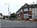
2
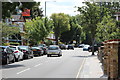
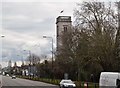
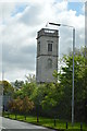
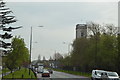
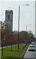
Erncroft Way, Twickenham
Suburban housing not far from the famous rugby stadium. The tower of All Hallows Church can be seen in the background.
Image: © Stephen McKay
Taken: 16 Dec 2010
0.05 miles
3
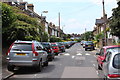
![Twickenham on match day [1]](https://s2.geograph.org.uk/geophotos/03/24/63/3246338_6784f783_120x120.jpg)
Twickenham on match day [1]
Crowds walking up Whitton Road for the rugby match. Portable toilets and urinals for their use in Heathfield North.
Image: © Christine Johnstone
Taken: 1 Dec 2012
0.05 miles
4
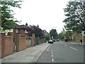
Chudleigh Rd
The street name sign has three streets on it as there are some short cul de sacs Such as Palmerston Rd, just off Chudleigh Rd on the south side of the Chertsey Rd, the A316. The short roads were originally longer but were cut in half by the construction of the A316 and their other halves, including half of Chudleigh Rd, are on the northern side of the A316. The road on the left is Whitton Rd. This is right on the southern edge of the grid square and the grid line runs along the line of the wall where the street sign is to the street lamp on the left so that the car is just out of square.
Image: © Nigel Mykura
Taken: 19 Sep 2010
0.05 miles