IMAGES TAKEN NEAR TO
Ferry Road, TEDDINGTON, TW11 9NH
Introduction
This page details the photographs taken nearby to Ferry Road, TW11 9NH by members of the Geograph project.
The Geograph project started in 2005 with the aim of publishing, organising and preserving representative images for every square kilometre of Great Britain, Ireland and the Isle of Man.

There are currently over 7.5m images from over14,400 individuals and you can help contribute to the project by visiting https://www.geograph.org.uk
Image Map
Images are licensed for reuse under creativecommons.org/licenses/by-sa/2.0
Notes
- Clicking on the map will re-center to the selected point.
- The higher the marker number, the further away the image location is from the centre of the postcode.
Image Listing (281 Images Found)
Images are licensed for reuse under creativecommons.org/licenses/by-sa/2.0
Image
Details
Distance
1
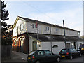
Boathouse Design Studio
A former boathouse on the Thames at Teddington Lock.
Image: © Stephen Craven
Taken: 14 Mar 2012
0.02 miles
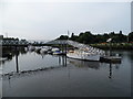
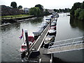
2
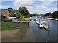
Teddington Lock
The lock and weir is the upper tidal limit of the Thames. This view is of the downstream side so is tidal.
Image: © Hugh Venables
Taken: 28 Jul 2012
0.02 miles
3
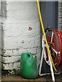
Benchmark on former boat house, Teddington Lock
This indistinct benchmark is on the north east face of the old boathouse at Teddington Lock. Ordnance Survey cut mark benchmark levelled at 5.270m above Newlyn Datum, verified 1957.
Image: © John S Turner
Taken: 9 May 2012
0.02 miles
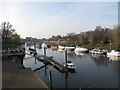
4
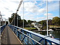
View from the Footbridge to the Boat Shop
Wikipedia : https://en.wikipedia.org/wiki/Teddington_Lock_Footbridges
Image: © James Emmans
Taken: 31 Aug 2016
0.03 miles
5
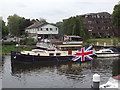
Teddington Riverbank
View from the footbridge of Si Solo. Union Jacks are prominent during the lead up to the Queen's Diamond Jubilee.
http://en.wikipedia.org/wiki/Teddington
Image: © Colin Smith
Taken: 31 May 2012
0.04 miles
6
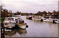
Boats at Teddington Lock
View from the footbridge downstream to Richmond upon Thames.
Image: © Stephen Williams
Taken: Unknown
0.04 miles
8
Boats moored near Teddington Weir
A view from the footbridge Image looking downstream.
Image: © Stephen Craven
Taken: 14 Mar 2012
0.04 miles
10
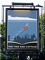
Pub sign: 'The Tide End Cottage', Teddington Lock
Being out in the weather, pub signs get repainted from time to time. If you're fond of an existing sign, the chances are the new one will be a disappointment. This sign brings the language of pub signs up to date, and I'd say it does so very effectively. The picture shows the evacuation of the British Expeditionary Force from Dunkirk in 1940 (and commemorates Teddington's own 'little ships'). But if you don't at first 'get' the historical background, the image is still a striking one: soldiers in their tin hats at the stern of the ship, the Red Ensign, the ship's wake, the sea and sky - and that's all, no wasted detail that can't be seen from street level.
The pub gets its name from its location - close to the highest point to which tides flow on the Thames.
Update, October 2014: could it be that the artist had a certain well-known paddle-steamer in mind when painting this sign? : Image
Image: © Stefan Czapski
Taken: 30 Jun 2012
0.04 miles