IMAGES TAKEN NEAR TO
Kingsmead Close, TEDDINGTON, TW11 9EP
Introduction
This page details the photographs taken nearby to Kingsmead Close, TW11 9EP by members of the Geograph project.
The Geograph project started in 2005 with the aim of publishing, organising and preserving representative images for every square kilometre of Great Britain, Ireland and the Isle of Man.

There are currently over 7.5m images from over14,400 individuals and you can help contribute to the project by visiting https://www.geograph.org.uk
Image Map
Images are licensed for reuse under creativecommons.org/licenses/by-sa/2.0
Notes
- Clicking on the map will re-center to the selected point.
- The higher the marker number, the further away the image location is from the centre of the postcode.
Image Listing (8 Images Found)
Images are licensed for reuse under creativecommons.org/licenses/by-sa/2.0
Image
Details
Distance
1
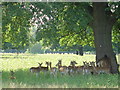
Deer sheltering from the noon day sun
In Bushy Park, near Hampton Court
Image: © steve
Taken: 11 Jun 2005
0.11 miles
2
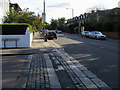
St Winifreds Road
Kingston Road passing St Winifreds Road
Image: © Shaun Ferguson
Taken: 8 Oct 2008
0.19 miles
5
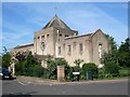
St Mark's Church, Teddington
Church of England parish church, serving South Teddington. See also Image
Image: © Christian K
Taken: Unknown
0.23 miles
6
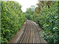
Kingston Loop line
Looking in the up direction, to Waterloo via Wimbledon. This is about the mid-point of the loop service from and to Waterloo operated on this line, the opposite direction going via Richmond.
Image: © Robin Webster
Taken: 16 Sep 2012
0.23 miles
7

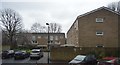
Bushy Park wall, Sandy Lane, Teddington
There is an Ordnance Survey benchmark on the white stone set into Bushy Park wall, Sandy Lane: Image
Image: © John S Turner
Taken: 12 May 2012
0.24 miles
8

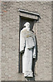
Benchmark by Sandy Lane, Teddington
Ordnance Survey benchmark set in Bushy Park wall by Sandy Lane, Teddington. For a wider view see: Image
Benchmark Database: https://www.bench-marks.org.uk/bm223863
Image: © John S Turner
Taken: 12 May 2012
0.24 miles