IMAGES TAKEN NEAR TO
Strathmore Road, TEDDINGTON, TW11 8UH
Introduction
This page details the photographs taken nearby to Strathmore Road, TW11 8UH by members of the Geograph project.
The Geograph project started in 2005 with the aim of publishing, organising and preserving representative images for every square kilometre of Great Britain, Ireland and the Isle of Man.

There are currently over 7.5m images from over14,400 individuals and you can help contribute to the project by visiting https://www.geograph.org.uk
Image Map
Images are licensed for reuse under creativecommons.org/licenses/by-sa/2.0
Notes
- Clicking on the map will re-center to the selected point.
- The higher the marker number, the further away the image location is from the centre of the postcode.
Image Listing (59 Images Found)
Images are licensed for reuse under creativecommons.org/licenses/by-sa/2.0
Image
Details
Distance
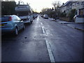
2
Fulwell Junction
Viewed from Stanley Road, Fulwell Junction on the Shepperton branch. Turn left for Richmond, right for Kingston.
Image: © Peter Kazmierczak
Taken: 21 Nov 2015
0.09 miles
4
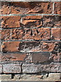
A crumbling bench mark in Stanley Road, Twickenham
This Ordnance Survey bench mark has deteriorated on its crumbling brickwork. The railway bridge to the left has been rebuilt, but this buttress is part of the old wall that borders the old tramway/bus depot in Stanley Road. See also Image
Image: © John S Turner
Taken: 12 May 2012
0.12 miles
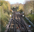
5
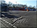
Tram Track at Fulwell
This is the entrance to Fulwell bus garage which was originally built for trams.
In the gateway the newer surface has been worn away to show the old yard paving and tram lines which obviously were never taken up.
For more about this place see Image
Image: © Des Blenkinsopp
Taken: 8 Feb 2011
0.12 miles
6
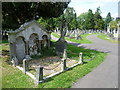
Teddington Cemetery
Teddington Cemetery was opened in 1879.
Image: © Marathon
Taken: 3 Aug 2011
0.12 miles
7
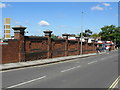
Old wall in Stanley Road, Twickenham
This old wall in Stanley Road, Twickenham bounds the old Tramway/Bus station. There is an Ordnance Survey bench mark on the first buttress on the left - Image
Image: © John S Turner
Taken: 12 May 2012
0.13 miles
9
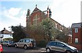
St Michael & St George, Wilcox Road, Fulwell
Image: © John Salmon
Taken: 5 Mar 2012
0.14 miles
10
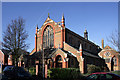
Saint Michael and Saint George
This church in Wilcox Road Fulwell was designed by J S Adkins and opened in 1913.
It is unusual in having a north - south alignment.
Image: © Des Blenkinsopp
Taken: 8 Feb 2011
0.14 miles