IMAGES TAKEN NEAR TO
Bushy Park, TEDDINGTON, TW11 0EW
Introduction
This page details the photographs taken nearby to Bushy Park, TW11 0EW by members of the Geograph project.
The Geograph project started in 2005 with the aim of publishing, organising and preserving representative images for every square kilometre of Great Britain, Ireland and the Isle of Man.

There are currently over 7.5m images from over14,400 individuals and you can help contribute to the project by visiting https://www.geograph.org.uk
Image Map
Images are licensed for reuse under creativecommons.org/licenses/by-sa/2.0
Notes
- Clicking on the map will re-center to the selected point.
- The higher the marker number, the further away the image location is from the centre of the postcode.
Image Listing (67 Images Found)
Images are licensed for reuse under creativecommons.org/licenses/by-sa/2.0
Image
Details
Distance
3
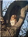
Tawny Owl (Strix aluco)
At least one bird regularly roosts here during the winter.
Image: © Hugh Venables
Taken: 18 Jan 2004
0.12 miles
5
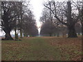
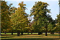
Chestnut Avenue, Bushy Park
Planned by Sir Christopher Wren, and first planted in 1699, as a grand approach to Hampton Court Palace. See http://www.royalparks.org.uk/parks/bushy_park/
Image: © Ceri Thomas
Taken: 27 Jan 2010
0.13 miles
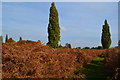
10
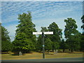
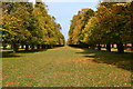
Cobbler's Walk comes up to Chestnut Avenue
Direction signs at t-junction of Cobbler's Walk and Chestnut Avenue in Bushy Park. Chestnut Avenue is a mile long, running from Teddington Gate to Loin Gate at Hampton Court. It bisects the park and was laid out by Christopher Wren, in 1713 during the reign of William III and Mary II. As you can see it is heavily lined by chestnut trees.
Image: © Sean Davis
Taken: 31 Jul 2010
0.16 miles