IMAGES TAKEN NEAR TO
Vancouver Road, RICHMOND, TW10 7YA
Introduction
This page details the photographs taken nearby to Vancouver Road, TW10 7YA by members of the Geograph project.
The Geograph project started in 2005 with the aim of publishing, organising and preserving representative images for every square kilometre of Great Britain, Ireland and the Isle of Man.

There are currently over 7.5m images from over14,400 individuals and you can help contribute to the project by visiting https://www.geograph.org.uk
Image Map
Images are licensed for reuse under creativecommons.org/licenses/by-sa/2.0
Notes
- Clicking on the map will re-center to the selected point.
- The higher the marker number, the further away the image location is from the centre of the postcode.
Image Listing (116 Images Found)
Images are licensed for reuse under creativecommons.org/licenses/by-sa/2.0
Image
Details
Distance
1
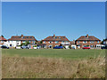
Houses on Burnell Avenue, Richmond
Looking from the river bank.
Image: © Robin Webster
Taken: 9 Sep 2012
0.08 miles

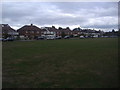
6
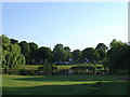
Ham Common
Taken from Ham Street of the pond on the west side of Ham common.
Image: © steve
Taken: 8 Jun 2005
0.11 miles
7
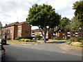
Ham - Beaufort Road
Beaufort Court Estate.
Image: © James Emmans
Taken: 31 Aug 2016
0.11 miles
8
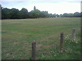
Green by Burnell Road, Ham
The River Thames is behind the trees.
Image: © David Howard
Taken: 18 Aug 2013
0.12 miles
9
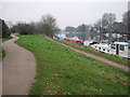
Riverside paths near Teddington Lock
The upper path is joint between cyclists and pedestrians, the lower is for pedestrians. Confusingly this swaps round further upriver.
Image: © Hugh Venables
Taken: 31 Dec 2008
0.12 miles
10

Not so old Boundary Marker in Kingston upon Thames
Municipal Boundary Marker on the west side of the cycle track, east of the River Thames towpath, and two metres east of SY_KIN01pb. On the boundary between the boroughs of Kingston upon Thames and Richmond upon Thames. Inscribed Royal (crown emblem) / Kingston / (three dolphins emblem) / This stone marks the boundary of The / Royal Borough of / Kingston upon / Thames and the London Borough of / Richmond upon Thames / ….1998.
Milestone Society National ID: SY_KIN02pb
Image: © C Woodward
Taken: Unknown
0.13 miles