IMAGES TAKEN NEAR TO
Back Lane, RICHMOND, TW10 7LA
Introduction
This page details the photographs taken nearby to Back Lane, TW10 7LA by members of the Geograph project.
The Geograph project started in 2005 with the aim of publishing, organising and preserving representative images for every square kilometre of Great Britain, Ireland and the Isle of Man.

There are currently over 7.5m images from over14,400 individuals and you can help contribute to the project by visiting https://www.geograph.org.uk
Image Map
Images are licensed for reuse under creativecommons.org/licenses/by-sa/2.0
Notes
- Clicking on the map will re-center to the selected point.
- The higher the marker number, the further away the image location is from the centre of the postcode.
Image Listing (91 Images Found)
Images are licensed for reuse under creativecommons.org/licenses/by-sa/2.0
Image
Details
Distance
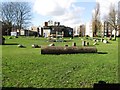
2
Corner of Ashburnham Road and Ham Street
Image: © David Howard
Taken: 16 Oct 2011
0.07 miles
3
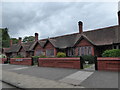
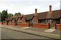
Tollemache Almshouses, Ham Street
The almshouses were built in 1892 in memory of Algernon Gray Tollemache
https://en.wikipedia.org/wiki/Algernon_Tollemache#Almshouses
Image: © Basher Eyre
Taken: 31 May 2017
0.07 miles
4

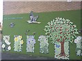
Commemorative plaque, Tollemache Almshouses, Ham Street
The plaque seems to have been built up as a mosaic, from gold-glazed tiles - and I was reminded of certain paintings by Gustav Klimt. As I passed by it was glinting in the late afternoon light - none the worse for 124 years' exposure to the elements.
Image: © Stefan Czapski
Taken: 11 Mar 2016
0.07 miles
5
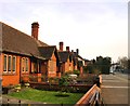
The Tollemache Almshouses, Ham Street
Founded in 1892.
Image: © Stefan Czapski
Taken: 11 Mar 2016
0.07 miles
6
Tollemache Almshouses on Ham Street
The almshouses were built in 1892 in memory of Algernon Gray Tollemache.
Image: © Steve Daniels
Taken: 30 May 2015
0.07 miles
7
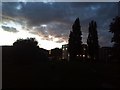
Ham Close at dusk
The housing estate from the adjacent village green.
Image: © David Howard
Taken: 23 Sep 2018
0.07 miles
10

Ham Street and the Ham Brewery Tap
View north-west, from a point close to the junction with Lock Road.
Not far behind the camera there's a cottage called Image, while the pub is known as the Brewery Tap. Those two names taken together amount to pretty good evidence that there was once a brewery here. The pub looks as if it dates from the 1920s or '30s - a period of rapid residential development around Ham and Petersham.
Image: © Stefan Czapski
Taken: 30 Jan 2016
0.09 miles