IMAGES TAKEN NEAR TO
Princes Road, RICHMOND, TW10 6DY
Introduction
This page details the photographs taken nearby to Princes Road, TW10 6DY by members of the Geograph project.
The Geograph project started in 2005 with the aim of publishing, organising and preserving representative images for every square kilometre of Great Britain, Ireland and the Isle of Man.

There are currently over 7.5m images from over14,400 individuals and you can help contribute to the project by visiting https://www.geograph.org.uk
Image Map
Images are licensed for reuse under creativecommons.org/licenses/by-sa/2.0
Notes
- Clicking on the map will re-center to the selected point.
- The higher the marker number, the further away the image location is from the centre of the postcode.
Image Listing (114 Images Found)
Images are licensed for reuse under creativecommons.org/licenses/by-sa/2.0
Image
Details
Distance
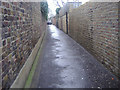
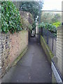
1
Worple Way, Richmond
One of a number of cottagey back doubles in this area. The street comes to a dead end, but the name then applies to a passageway that continues to King's Road and beyond. The name Worple Way suggests a medieval origin, as a track leading to the parish's open fields.
Image: © Stefan Czapski
Taken: 13 Jul 2014
0.01 miles

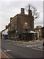
5
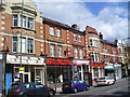
Sheen Road
Street level shops with flats above on the main road leading east from Richmond.
Image: © Colin Smith
Taken: 29 Mar 2009
0.05 miles
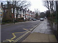
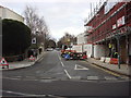
9
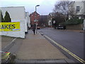
Kings Road Richmond
Looking at junction of Sheen Road
Image: © David Howard
Taken: 21 Feb 2011
0.07 miles