IMAGES TAKEN NEAR TO
Houblon Road, RICHMOND, TW10 6DE
Introduction
This page details the photographs taken nearby to Houblon Road, TW10 6DE by members of the Geograph project.
The Geograph project started in 2005 with the aim of publishing, organising and preserving representative images for every square kilometre of Great Britain, Ireland and the Isle of Man.

There are currently over 7.5m images from over14,400 individuals and you can help contribute to the project by visiting https://www.geograph.org.uk
Image Map
Images are licensed for reuse under creativecommons.org/licenses/by-sa/2.0
Notes
- Clicking on the map will re-center to the selected point.
- The higher the marker number, the further away the image location is from the centre of the postcode.
Image Listing (93 Images Found)
Images are licensed for reuse under creativecommons.org/licenses/by-sa/2.0
Image
Details
Distance
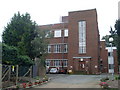
2
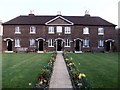
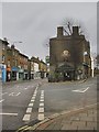
The Houblon Almshouses, Richmond
The formal design, the dark brickwork, and the small first-floor windows all contribute to a rather stern impression - a little barracks. A tablet over the porch in the middle dates the building to 1758, and reads as follows:
THESE ALMS-HOUSES WERE ERECTED AND ENDOWED BY MRS. REBECCA AND MRS. SUSANNAH HOUBLON
M.DCC.LVIII
The site lies on the boundary of the grid-square. The 1:25,000 sheet suggests that it belongs in this square rather then the next to the north.
Image: © Stefan Czapski
Taken: 20 Mar 2011
0.06 miles
3
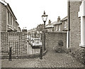
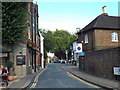
End of Houblon Road
Houblon Road is a no through road for vehicles but there is pedestrian access through to Church Road.
Image: © Des Blenkinsopp
Taken: 19 Oct 2017
0.06 miles
4
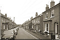
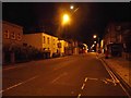
Prince's Road, Richmond
For the most part a street of early-Victorian terraced cottages. In the middle distance the building with the high Dutch-style gable was originally a school. In the foreground, plenty of evidence of a brisk housing market in this part of the world.
Image: © Stefan Czapski
Taken: 13 Jul 2014
0.07 miles
5
Worple Way, East Sheen
Worple Way in East Sheen, near Richmond-upon-Thames.
Image: © Malc McDonald
Taken: 3 Aug 2014
0.07 miles
6
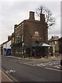
The Red Cow, Sheen Road - Christmas Eve 2016
In central Richmond the larger shops were open, but away from the centre smaller businesses had already closed for the holiday. Sheen Road seemed all but deserted, almost unnaturally quiet.
Image: © Stefan Czapski
Taken: 24 Dec 2016
0.08 miles
9
Richmond Kew Telephone Exchange
Situated in Spring Terrace off the A305 Sheen Road, this TE dates from the late 1930s and used to have RIChmond numbers until the late 1960s. Now it has 0208-332, 940 and 948 numbers. Its postcode is TW9 1LW.
Image: © David Hillas
Taken: 4 Aug 2009
0.10 miles
10
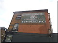
Ghost sign on the corner of Alton Road, Richmond
This has been partly covered and was painted over another sign which is coming through.
Image: © David Howard
Taken: 8 Feb 2016
0.11 miles