IMAGES TAKEN NEAR TO
Newton Under Roseberry, MIDDLESBROUGH, TS9 6QS
Introduction
This page details the photographs taken nearby to TS9 6QS by members of the Geograph project.
The Geograph project started in 2005 with the aim of publishing, organising and preserving representative images for every square kilometre of Great Britain, Ireland and the Isle of Man.

There are currently over 7.5m images from over14,400 individuals and you can help contribute to the project by visiting https://www.geograph.org.uk
Image Map
Images are licensed for reuse under creativecommons.org/licenses/by-sa/2.0
Notes
- Clicking on the map will re-center to the selected point.
- The higher the marker number, the further away the image location is from the centre of the postcode.
Image Listing (33 Images Found)
Images are licensed for reuse under creativecommons.org/licenses/by-sa/2.0
Image
Details
Distance
1
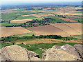
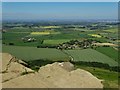
Newton under Roseberry
The foreground rocks are on the summit of Roseberry Topping, and the nearest corner of Newton is in the same gridsquare, which is met by Roseberry Lane. The farmland field system is well defined in this view.
Image: © Peter Church
Taken: 6 Aug 2006
0.01 miles
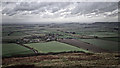
2
Newton under Roseberry from Roseberry Topping
Image: © Bill Boaden
Taken: 13 Jul 2009
0.03 miles
3
On a windswept Roseberry Common
Not many visitors climbing Roseberry today. There will be plenty of car parking down in Newton. On popular days parking is becoming very difficult. Folk are reluctant to use the National Park run carpark because of the cost preferring instead to park on the verges. There are proposals to introduce double yellow lines and an extension to the car park. Meanwhile, on the village green, the Kings Head will be serving refreshments just as it did for Walter White in 1858 during his “Month in Yorkshire” after his two-hour loiter on the summit reflecting on the distant smoke from the industries and smelting furnaces of Middlesbrough.
From my blog http://www.fhithich.uk/?p=20581
Image: © Mick Garratt
Taken: 18 Dec 2018
0.04 miles
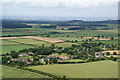
4
View from the top
The harvested field to the left, the lane and the first buildings of Newton under Roseberry are all in the same square as these summit rocks of Roseberry Topping. The view extends north-westwards towards Middlesbrough, which must be lovely on a clear day.
Image: © Graham Horn
Taken: 7 Sep 1999
0.04 miles
5
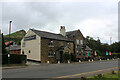
The King's Head, Newton-under-Roseberry
Hostelry on the main A173, near Great Ayton
Image: © Chris Heaton
Taken: 4 Jul 2022
0.05 miles
6
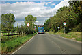
Entering Newton under Roseberry
A very small village, but a largish car park on the right for walkers up and around Roseberry Topping.
Image: © Robin Webster
Taken: 7 Oct 2011
0.06 miles
7
Newton-under-Roseberry seen from Roseberry Topping
Image: © Neil Theasby
Taken: 17 Jun 2017
0.06 miles
8
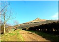
Roseberry Topping
Roseberry Topping from Newton Lane
Image: © margaret grant
Taken: 19 Mar 2015
0.07 miles
9
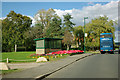
Village green and bus shelter, Newton under Roseberry
A colourful flowerbed in the afternoon sun
Image: © Robin Webster
Taken: 7 Oct 2011
0.07 miles
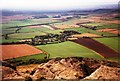
10
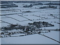
Newton under Roseberry from Roseberry Topping
This photograph shows a view of the village of Newton under Roseberry from the top of Roseberry Topping. The picture was taken after a heavy fall of snow. At the top of the picture it is possible to see the south-western edge of the village of Nunthorpe.
Image: © Philip Barker
Taken: 20 Dec 2009
0.08 miles