IMAGES TAKEN NEAR TO
Ainsworth Way, MIDDLESBROUGH, TS7 9QB
Introduction
This page details the photographs taken nearby to Ainsworth Way, TS7 9QB by members of the Geograph project.
The Geograph project started in 2005 with the aim of publishing, organising and preserving representative images for every square kilometre of Great Britain, Ireland and the Isle of Man.

There are currently over 7.5m images from over14,400 individuals and you can help contribute to the project by visiting https://www.geograph.org.uk
Image Map
Images are licensed for reuse under creativecommons.org/licenses/by-sa/2.0
Notes
- Clicking on the map will re-center to the selected point.
- The higher the marker number, the further away the image location is from the centre of the postcode.
Image Listing (6 Images Found)
Images are licensed for reuse under creativecommons.org/licenses/by-sa/2.0
Image
Details
Distance
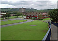
1
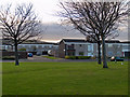
Spencerbeck estate
Looking to Ainsworth Way
Image: © Stephen McCulloch
Taken: 10 Dec 2008
0.04 miles
2
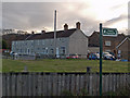
Spencer Beck Farm
Farm situated on Normanby Road.
Image: © Stephen McCulloch
Taken: 10 Dec 2008
0.13 miles
3
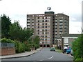
Ellerbeck Way, Ormesby
With Spencerbeck House at the bottom.
Image: © Mick Garratt
Taken: 17 Sep 2005
0.16 miles
4
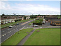
Normanby Road
Looking along Normanby Road, showing its junction with Allendale Road.
St Gabriel's Church is on the right.
On the skyline can be seen Corus' Lackenby steelworks (between the 2 lampposts) and cooling towers from the Wilton chemical site.
Image: © Stephen McCulloch
Taken: 26 Jun 2007
0.17 miles
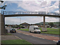
5
View from the bridge
The closer road is Thursby Drive, leading onto Allendale Road. Wetherby Green runs to the right of the houses.
On the left of the picture is St Gabriel's RC Primary School. The tower block is Spencerbeck House.
Update: This view is no more. The bridge was demolished in May 2008.
Image: © Stephen McCulloch
Taken: 26 Jun 2007
0.21 miles
6
Footbridge over Normanby Road
Bridge linking Netherfields and Overfields estates.
Under the bridge can be seen St Gabriel's church and school to its right, with Eston Hills in the distance.
Update: The footbridge was demolished in May 2008.
Image: © Stephen McCulloch
Taken: 26 Jun 2007
0.23 miles