IMAGES TAKEN NEAR TO
TRIMDON STATION, TS29 6NU
Introduction
This page details the photographs taken nearby to TS29 6NU by members of the Geograph project.
The Geograph project started in 2005 with the aim of publishing, organising and preserving representative images for every square kilometre of Great Britain, Ireland and the Isle of Man.

There are currently over 7.5m images from over14,400 individuals and you can help contribute to the project by visiting https://www.geograph.org.uk
Image Map
Images are licensed for reuse under creativecommons.org/licenses/by-sa/2.0
Notes
- Clicking on the map will re-center to the selected point.
- The higher the marker number, the further away the image location is from the centre of the postcode.
Image Listing (8 Images Found)
Images are licensed for reuse under creativecommons.org/licenses/by-sa/2.0
Image
Details
Distance
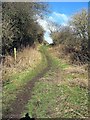
4
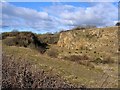
Entrance to Wingate Quarry Local Nature reserve
A disused limestone quarry now a Site of Special Scientific Interest (SSSI)
Image: © George Ford
Taken: 6 Jun 2005
0.13 miles
6
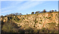
Quarry face at Old Wingate
This is Wingate Quarry which was worked for magnesian limestone until the 1930s. It and the area south of it is now a Local Nature Reserve, the first of those to be established in County Durham. It's also an SSSI.
Image: © Trevor Littlewood
Taken: 18 Jan 2020
0.16 miles
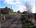
7
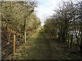
Route of tramway at Wingate Quarry
Along here a tramway once ran. This connected Wingate Quarry to the railway at Trimdon, via Deaf Hill Colliery. A few old fence posts remain, and recently this area has been re-fenced as a footpath open to the public.
Image: © Roger Muggleton
Taken: 21 Feb 2021
0.19 miles
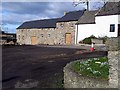
8
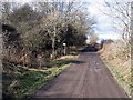
Farm Track bisecting east and west sections of Wingate Quarry
Image: © Roger Smith
Taken: 22 Feb 2009
0.19 miles