IMAGES TAKEN NEAR TO
Telford Close, HARTLEPOOL, TS24 0UE
Introduction
This page details the photographs taken nearby to Telford Close, TS24 0UE by members of the Geograph project.
The Geograph project started in 2005 with the aim of publishing, organising and preserving representative images for every square kilometre of Great Britain, Ireland and the Isle of Man.

There are currently over 7.5m images from over14,400 individuals and you can help contribute to the project by visiting https://www.geograph.org.uk
Image Map
Images are licensed for reuse under creativecommons.org/licenses/by-sa/2.0
Notes
- Clicking on the map will re-center to the selected point.
- The higher the marker number, the further away the image location is from the centre of the postcode.
Image Listing (9 Images Found)
Images are licensed for reuse under creativecommons.org/licenses/by-sa/2.0
Image
Details
Distance
2
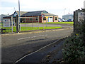
Entrance to Hartlepool Dock Main Offices
Off Cleveland Road, A1048.
Image: © Oliver Dixon
Taken: 19 Nov 2015
0.07 miles
4
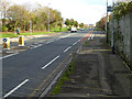
Cleveland Road, Hartlepool
A rather dreary section of the England Coast Path follows the pavement of Cleveland Road, A1048, on the south side through from Hartlepool to the Headland.
Image: © Oliver Dixon
Taken: 19 Nov 2015
0.13 miles
5
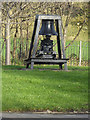
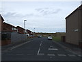
Bell Buoy, West View Road
This piece of public artwork, comprising a bell buoy commemorating Hartlepool's maritime history was erected at the junction of Cleveland Road and West View Road about fifteen years ago. Despite weighing a tonne, someone managed to steal it on 20th January, 2018.
Image: © Oliver Dixon
Taken: 19 Nov 2015
0.13 miles
6
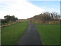
Footpath parallel to Old Cemetery Road
Follows the line of the former Hartlepool Dock and railway line opened in 1835 and finally closed in 1969.
Image: © Jonathan Thacker
Taken: 29 Nov 2012
0.17 miles
7
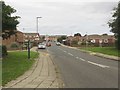
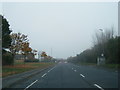
Cleveland Road, Hartlepool
Looking along the A1048, Cleveland Road, in Hartlepool.
Image: © Graham Robson
Taken: 11 Sep 2018
0.21 miles
8
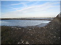
Abandoned factory site
Recent heavy rain has left shallow pools of water.
Image: © Jonathan Thacker
Taken: 29 Nov 2012
0.22 miles
9

Derelict Industrial Warehousing
Part of the partially demolished Steetley Magnesite Works (for further info. see http://www.geograph.org.uk/photo/614209).
Image: © Mick Garratt
Taken: 23 Nov 2007
0.24 miles