IMAGES TAKEN NEAR TO
Boundary Road, MIDDLESBROUGH, TS1 5AQ
Introduction
This page details the photographs taken nearby to Boundary Road, TS1 5AQ by members of the Geograph project.
The Geograph project started in 2005 with the aim of publishing, organising and preserving representative images for every square kilometre of Great Britain, Ireland and the Isle of Man.

There are currently over 7.5m images from over14,400 individuals and you can help contribute to the project by visiting https://www.geograph.org.uk
Image Map (Loading...)


Getting Data...Please wait
Leaflet Map data © OpenStreetMap
Images are licensed for reuse under creativecommons.org/licenses/by-sa/2.0
Notes
- Clicking on the map will re-center to the selected point.
- The higher the marker number, the further away the image location is from the centre of the postcode.
Image Listing (72 Images Found)
Images are licensed for reuse under creativecommons.org/licenses/by-sa/2.0
Image
Details
Distance
1
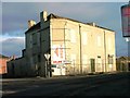
Derelict Building, Corner of Stockton Street and Bridge Street West
An 1866 map shows a public house on this corner. The building looks the right period. I would be interested in knowing its name. This building has now been demolished.
Image: © Mick Garratt
Taken: 16 Dec 2005
0.02 miles
2
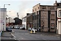
Marsh Road
There are plans afoot to turn the burnt out shell of a former bedroom warehouse on the right into a pub and nightclub operating everyday from 11am to 4am.
Image: © Mick Garratt
Taken: 14 Nov 2007
0.03 miles
3
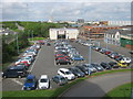
Station Road car park in Middlesbrough
Seen from the multi-storey section
Image: © Peter Robinson
Taken: 22 May 2013
0.06 miles
4
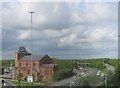
The A66 passing through central Middlesbrough
The Church of St Columba in Wilson Street is adjacent
Image: © Peter Robinson
Taken: 22 May 2013
0.09 miles
5
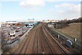
Railway tracks near Metz Bridge (view east)
This photograph shows a view of railway tracks approaching and leaving Middlesbrough. The picture was taken from the Metz Road bridge looking in a east-north-easterly direction towards Middlesbrough Dock. The Tees transporter bridge occupies a prominent position on the horizon to the left of the railway and the Zetland multi-storey car park can be seen on the right.
Image: © Philip Barker
Taken: 4 Mar 2010
0.12 miles
6
A66, Middlesbrough
The elevated A66 effectively bisects the town. Taken from the top of the Zetland car park.
Image: © Mick Garratt
Taken: 6 Nov 2006
0.12 miles
7
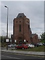
Middlesbrough: parish church of St. Columba
Looking somewhat out of place alongside a busy dual carriageway and large supermarket and filling station.
Image: © Chris Downer
Taken: 1 May 2008
0.13 miles
8
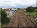
Railway lines towards Middlesbrough
The Transporter Bridge dominates the skyline.
Image: © Nigel Thompson
Taken: 29 Jul 2019
0.13 miles
9
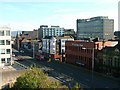
New developments in Bridge Street West (4)
North of Middlesbrough station has largely been derelict for many years but gradually new buildings are being constructed. Each seems to be trying to vie for prominence making for a restless visual experience.
Image: © Jonathan Thacker
Taken: 1 Dec 2012
0.13 miles
10
New developments in Bridge Street West (5)
North of Middlesbrough station has largely been derelict for many years but gradually new buildings are being constructed. Each seems to be trying to vie for prominence making for a restless visual experience.
Image: © Jonathan Thacker
Taken: 1 Dec 2012
0.14 miles