IMAGES TAKEN NEAR TO
Rubble Lane, NEWQUAY, TR7 1QE
Introduction
This page details the photographs taken nearby to Rubble Lane, TR7 1QE by members of the Geograph project.
The Geograph project started in 2005 with the aim of publishing, organising and preserving representative images for every square kilometre of Great Britain, Ireland and the Isle of Man.

There are currently over 7.5m images from over14,400 individuals and you can help contribute to the project by visiting https://www.geograph.org.uk
Image Map
Images are licensed for reuse under creativecommons.org/licenses/by-sa/2.0
Notes
- Clicking on the map will re-center to the selected point.
- The higher the marker number, the further away the image location is from the centre of the postcode.
Image Listing (13 Images Found)
Images are licensed for reuse under creativecommons.org/licenses/by-sa/2.0
Image
Details
Distance
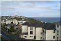
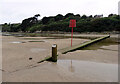
1
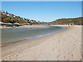
The Gannel estuary at low tide, Crantock
The River Gannel meets the sea, still flowing fast over the sand. The fine houses of Pentire look down from the cliff top
Image: © Derek Voller
Taken: 2 May 2016
0.06 miles
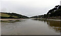
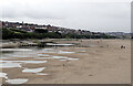
2
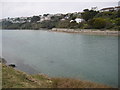
The Gannel estuary
The Gannel estuary with a falling tide viewed from to the north of Gannel.
Image: © Philip Halling
Taken: 24 Apr 2010
0.06 miles
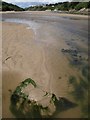
3
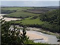
The Gannel
A tidal estuary on the south side of Newquay, seen from Riverside Avenue. The slope in the centre of the photo looks like a raised beach.
Image: © Derek Harper
Taken: 3 Jul 2008
0.13 miles
4
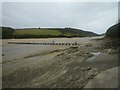
The Gannel Footbridge and Estuary
The footbridge carries the South West Coast Path across the estuary, but is only exposed for a period each side of low tide.
Image: © Maurice D Budden
Taken: 6 Sep 2011
0.16 miles
5
The view west from the Fistral Bay Hotel
From room 205.
Image: © David Long
Taken: 9 May 2006
0.16 miles
6
The River Gannel seen from the tidal footbridge
The footbridge carries The South West Coast Path over the River Gannel at low tide.
Image: © habiloid
Taken: 30 Jul 2013
0.18 miles
7
The Gannel estuary
A view along The Gannel from the long low footbridge that carries the South West Coast Path.
Image: © Derek Harper
Taken: 3 Jul 2008
0.22 miles
8
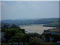
The Gannel Channel
The Gannel looking across from Pentire to Treringay
Image: © Roger Crowther
Taken: 5 Sep 2005
0.23 miles
9
Tidal footbridge over The Gannel
This footbridge carries The South West Coast Path over the River Gannel at low tide.
Image: © habiloid
Taken: 30 Jul 2013
0.23 miles
10
Tidal footbridge over The Gannel
This footbridge carries The South West Coast Path over the River Gannel at low tide.
Image: © habiloid
Taken: 30 Jul 2013
0.23 miles