IMAGES TAKEN NEAR TO
ST. AGNES, TR5 0NW
Introduction
This page details the photographs taken nearby to TR5 0NW by members of the Geograph project.
The Geograph project started in 2005 with the aim of publishing, organising and preserving representative images for every square kilometre of Great Britain, Ireland and the Isle of Man.

There are currently over 7.5m images from over14,400 individuals and you can help contribute to the project by visiting https://www.geograph.org.uk
Image Map
Images are licensed for reuse under creativecommons.org/licenses/by-sa/2.0
Notes
- Clicking on the map will re-center to the selected point.
- The higher the marker number, the further away the image location is from the centre of the postcode.
Image Listing (20 Images Found)
Images are licensed for reuse under creativecommons.org/licenses/by-sa/2.0
Image
Details
Distance
2
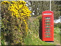
Roadside telephone box at Higher Goonvrea
The newly-painted telephone box and the gorse blossom making a beautiful splash of colour.
Image: © Rod Allday
Taken: 5 May 2013
0.12 miles
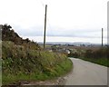
3
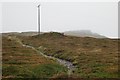
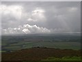
St Agnes Beacon, southern slope
Looking up into the cloud covering the top of St Agnes Beacon.
Image: © Tony Atkin
Taken: 22 Oct 2005
0.12 miles
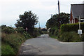
4
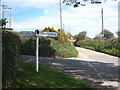
Road junction
Crossroads near St Agnes
Image: © Robert Ashby
Taken: 17 Aug 2014
0.13 miles
5
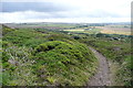
Footpath towards Bolster
This is on the southern side of the St Agnes Beacon open access area, owned by the National Trust. Moorland paths abound, leading down to pastures and arable land.
Image: © Graham Horn
Taken: 8 Jul 2011
0.14 miles
7
Rain - Clearing
A view south from St Agnes Beacon in improving weather conditions.
Image: © Tony Atkin
Taken: 22 Oct 2005
0.15 miles
8
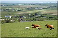
Pasture, St Agnes
Cattle on the eastern flank of St Agnes Beacon.
Image: © Andrew Smith
Taken: 8 May 2022
0.15 miles
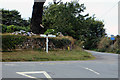
9
Cornish hedges south of Bolster
Looking from the crossroads at Bolster, with banks and hedges on each side of the road
Image: © David Smith
Taken: 11 Mar 2016
0.15 miles
10
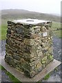
GPS Reference Station on St Agnes Beacon
In the old days this was a Triangulation Pillar. Now it can be used as an accurately located reference point for GPS Surveys. A GPS receiver can be placed on here as a reference station while at the same time a roving receiver can do the actual surveying. Most of the positional inaccuracies in the signals received from the GPS satellites will be recorded equally by both stations but since this is at a known location, data recorded here can be used to cancel out inaccuracies in the data received by the roving station.
Image: © Tony Atkin
Taken: 22 Oct 2005
0.16 miles