IMAGES TAKEN NEAR TO
Forthvean Road, TRURO, TR4 8AY
Introduction
This page details the photographs taken nearby to Forthvean Road, TR4 8AY by members of the Geograph project.
The Geograph project started in 2005 with the aim of publishing, organising and preserving representative images for every square kilometre of Great Britain, Ireland and the Isle of Man.

There are currently over 7.5m images from over14,400 individuals and you can help contribute to the project by visiting https://www.geograph.org.uk
Image Map
Images are licensed for reuse under creativecommons.org/licenses/by-sa/2.0
Notes
- Clicking on the map will re-center to the selected point.
- The higher the marker number, the further away the image location is from the centre of the postcode.
Image Listing (4 Images Found)
Images are licensed for reuse under creativecommons.org/licenses/by-sa/2.0
Image
Details
Distance
1
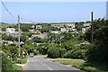
Housing above Porthtowan
This loose cluster of houses has developed around the head of a steep coombe which runs down to the main valley at Porthtowan.
Image: © Tony Atkin
Taken: 15 Jun 2006
0.06 miles
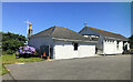
2
The Chapel on the Hill
As the name suggests, Porthtowan's active methodist church is situated on the plateau land at the head of a steep valley to the southwest of the village and high above it.
Image: © Tony Atkin
Taken: 15 Jun 2006
0.16 miles
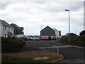
3
Chapel on the Hill (Porthtowan Methodist)
Image: © Paul Barnett
Taken: 1 Jan 2022
0.18 miles
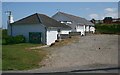
4
New houses at Porthtowan
The same ones as in Tony Atkin's photo Image but now completed.
Image: © Rod Allday
Taken: 9 May 2010
0.25 miles