IMAGES TAKEN NEAR TO
Vorvas, ST. IVES, TR26 3HL
Introduction
This page details the photographs taken nearby to Vorvas, TR26 3HL by members of the Geograph project.
The Geograph project started in 2005 with the aim of publishing, organising and preserving representative images for every square kilometre of Great Britain, Ireland and the Isle of Man.

There are currently over 7.5m images from over14,400 individuals and you can help contribute to the project by visiting https://www.geograph.org.uk
Image Map
Images are licensed for reuse under creativecommons.org/licenses/by-sa/2.0
Notes
- Clicking on the map will re-center to the selected point.
- The higher the marker number, the further away the image location is from the centre of the postcode.
Image Listing (21 Images Found)
Images are licensed for reuse under creativecommons.org/licenses/by-sa/2.0
Image
Details
Distance
1
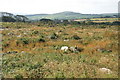
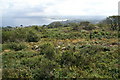
Scrubland south of Knill's Monument
Looking towards Vorvas Vean from the monument. In the distance is Trencrom Hill, Image
Image: © Pierre Terre
Taken: 25 Jul 2008
0.10 miles
2
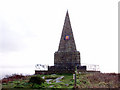
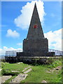
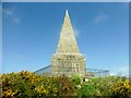
Knill's Monument
On a hill above St Ives, at 170m, with an excellent view of Carbis Bay to the east.
Image: © Sheila Russell
Taken: 18 Jan 2006
0.14 miles
3
Knill's Monument
Also known as Knill's Steeple. A granite monument to John Knill, built in 1782, though the modest man himself died in 1811 and was buried in Holborn. Every 5th year on St James's Day (25th July), a fiddler playing the Furry Dance leads two elderly widows and ten young girls in a dance around the monument. The ceremony is due next on the 200th anniversary in 2011.
Image: © Pierre Terre
Taken: 25 Jul 2008
0.14 miles
4
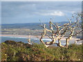
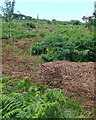
A dead tree amongst the heathland on Trelyon Downs
The downs have a commanding view across St Ives Bay.
Image: © Rod Allday
Taken: 1 Dec 2012
0.15 miles
5
Near Knill's Monument
Looking east towards St Ives Bay and Hayle Towans.
Image: © Pierre Terre
Taken: 25 Jul 2008
0.16 miles
6
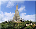
Towards Knill's Monument
There are many paths in this area, with bracken covered ground between. On top of the hill is Knill's Monument, and although there is no path visible here the monument is actually very accessible.
Image: © Graham Horn
Taken: 2 Jul 2011
0.16 miles
8
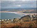
Heathland on Trelyon Downs
A high point overlooking St Ives Bay and the Hayle Estuary.
Image: © Rod Allday
Taken: 1 Dec 2012
0.17 miles
9
Knill's Monument
A drive along narrow roads from Tink Hill. Parked near reservoir compound then gentle stroll to summit through the gorse.
Name: Knill's Monument
Hill number: 17666
Height: 170m / 558ft
Parent (Ma/M): 2887 Watch Croft [White Downs]
Section: 40: Cornwall & Devon
County/UA: Cornwall (CoU)
Class: Tump (100-199m)
Grid ref: SW 51634 38672
Summit feature: ground at base of monument
Drop: 37m
Col: 133m SW507380
Image: © Rude Health
Taken: 6 May 2015
0.17 miles
10

Knill's Monument
A 50' high granite pyramid also known as Knill's Steeple. Intended to be a mausoleum for John Knill. a Customs Officer and Mayor of St Ives who left the town to take a post as Customs Officer in the West Indies where, rumour has it, he made a small fortune. However, he died at Gray's Inn Square on March 29th 1811 and was subsequently buried at St. Andrews Church, Holborn. More details are available here: http://www.stives-cornwall.co.uk/st-ives-history-2.html
Image: © Rod Allday
Taken: 1 Dec 2012
0.17 miles