IMAGES TAKEN NEAR TO
Telegraph, ISLES OF SCILLY, TR21 0NP
Introduction
This page details the photographs taken nearby to Telegraph, TR21 0NP by members of the Geograph project.
The Geograph project started in 2005 with the aim of publishing, organising and preserving representative images for every square kilometre of Great Britain, Ireland and the Isle of Man.

There are currently over 7.5m images from over14,400 individuals and you can help contribute to the project by visiting https://www.geograph.org.uk
Image Map
Images are licensed for reuse under creativecommons.org/licenses/by-sa/2.0
Notes
- Clicking on the map will re-center to the selected point.
- The higher the marker number, the further away the image location is from the centre of the postcode.
Image Listing (19 Images Found)
Images are licensed for reuse under creativecommons.org/licenses/by-sa/2.0
Image
Details
Distance
1
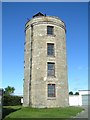
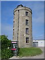
Corsican Tower, Telegraph
Built 1814 and the site of an "optical telegraph" using semaphore to communicate with the mainland - see http://www.porthcurno.org.uk/html/messages2.html - also the highest point on St. Mary's.
Image: © Dave Dunford
Taken: 22 Oct 2005
0.02 miles
2
Former Coastguard's Lookout Station
Grade II listed https://www.historicengland.org.uk/listing/the-list/list-entry/1141182
Image: © Oast House Archive
Taken: 23 Jun 2017
0.05 miles
3
Former Coastguard's Lookout Station
Grade II listed https://www.historicengland.org.uk/listing/the-list/list-entry/1141182
Image: © Oast House Archive
Taken: 23 Jun 2017
0.05 miles
4
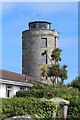
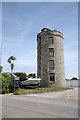
Telegraph Tower in 1998
This historic aid to communication dwarfs the modern equivalent telephone box nearby.
Image: © Ruth Riddle
Taken: 29 Aug 1998
0.05 miles
5
Modern Communications Tower at the Telegraph
The Telegraph on St Mary's is famous for its tall transmission mast, which acts as a landmark over much of the islands. However, modern communications are now through these less conspicuous, but more efficient dish aerials.
Image: © John Rostron
Taken: 21 Jun 2013
0.05 miles
6
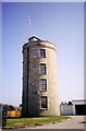
Telegraph Tower
One of three gun towers proposed and built on St.Mary's by Major Daniel Lyman in 1803. It stands at the highest point in the Isles of Scilly, 165 feet above sea level and is now used as a coastguard lookout tower.
It reputedly got its name after 1898 when Marconi successfully received wireless signals here from Porthcumo in Cornwall, 30 miles away
Image: © Richard Croft
Taken: 30 Jun 2010
0.06 miles
7
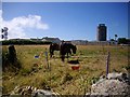
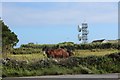
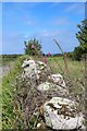
Proposed building site, Telegraph, St. Mary's
In the local plan this has been allocated for local need and key worker housing.
There is a proposal to develop this field of 0.34ha adjoining the Coastguard Bungalows in Telegraph. It should be capable of accommodating a minimum of 15 houses and a social facility such as a shop or a pub.
Image: © Bob Embleton
Taken: 7 Aug 2008
0.08 miles
8
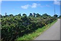
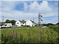
Towers of Telegraph, St. Mary's
Looking from Pungies Lane towards three towers close together in the hamlet known as Telegraph. The granite round tower in the centre was built on the highest point of the island as a gun and semaphore tower soon after 1805 and later adapted as a signal station. In 1898 Marconi received radio signals here from Portcurno 30 miles away. A more modern coastguard transmitter mast is on the right and an inter island microwave telecoms link can be seen on the left.
Image: © Bob Embleton
Taken: 7 Aug 2008
0.08 miles