IMAGES TAKEN NEAR TO
Gitchell Lane, PENZANCE, TR20 9ES
Introduction
This page details the photographs taken nearby to Gitchell Lane, TR20 9ES by members of the Geograph project.
The Geograph project started in 2005 with the aim of publishing, organising and preserving representative images for every square kilometre of Great Britain, Ireland and the Isle of Man.

There are currently over 7.5m images from over14,400 individuals and you can help contribute to the project by visiting https://www.geograph.org.uk
Image Map (Loading...)


Getting Data...Please wait
Leaflet Map data © OpenStreetMap
Images are licensed for reuse under creativecommons.org/licenses/by-sa/2.0
Notes
- Clicking on the map will re-center to the selected point.
- The higher the marker number, the further away the image location is from the centre of the postcode.
Image Listing (32 Images Found)
Images are licensed for reuse under creativecommons.org/licenses/by-sa/2.0
Image
Details
Distance
1
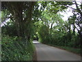
National Cycle Route 3
Looking south west - Rosevidney.
Image: © JThomas
Taken: 13 Jul 2017
0.05 miles
2
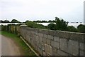
The bridge
Having got lost on the way to St Ives, we stopped on a railway bridge to see where we were. Still not sure so used the GPS. Found we were at SW5294633962. This is the view from the bridge looking SE. Yards and yards of plastic sheeting.
Image: © Ken Ballinger
Taken: 13 Sep 2005
0.05 miles
3
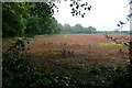
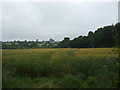
Farmland at Rosevidney
Whatever was in this field, something reddish, has been harvested.
Image: © Graham Horn
Taken: 6 Jul 2011
0.05 miles
9
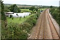
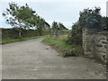
From the Bridge
Having got lost on the way to St Ives, we stopped on a railway bridge to see where we were. Still not sure so used the GPS. Found we were at SW5294633962. This is the railway line going NE from Penzance.
Image: © Ken Ballinger
Taken: 13 Sep 2005
0.09 miles
10
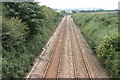
The Railway line
Having got lost on the way to St Ives, we stopped on a railway bridge to see where we were. Still not sure so used the GPS. Found we were at SW5294633962. This is the railway line going SW to Penzance.
Image: © Ken Ballinger
Taken: 13 Sep 2005
0.09 miles