IMAGES TAKEN NEAR TO
Kenneggy Downs, PENZANCE, TR20 9AW
Introduction
This page details the photographs taken nearby to Kenneggy Downs, TR20 9AW by members of the Geograph project.
The Geograph project started in 2005 with the aim of publishing, organising and preserving representative images for every square kilometre of Great Britain, Ireland and the Isle of Man.

There are currently over 7.5m images from over14,400 individuals and you can help contribute to the project by visiting https://www.geograph.org.uk
Image Map (Loading...)


Getting Data...Please wait
Leaflet Map data © OpenStreetMap
Images are licensed for reuse under creativecommons.org/licenses/by-sa/2.0
Notes
- Clicking on the map will re-center to the selected point.
- The higher the marker number, the further away the image location is from the centre of the postcode.
Image Listing (16 Images Found)
Images are licensed for reuse under creativecommons.org/licenses/by-sa/2.0
Image
Details
Distance
1
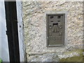
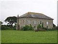
Ordnance Survey Flush Bracket 11816
This bracket can be found on the wall of The Coach and Horses Inn at Kenneggy. The benchmark height is recorded as being 79.993 metres above sea level. [The Os have this in SW5629 (SW 5699 2818) whilst my GPS had it in SW5729 (SW 57003 29194) - take your pick]
For more detail see : http://www.bench-marks.org.uk/bm11686
Image: © Peter Wood
Taken: 30 Apr 2017
0.01 miles
2
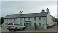
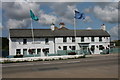
The Coach and Horses Public House
This 18th C public house is Grade II listed with English Heritage Building ID: 65775. See also: http://www.britishlistedbuildings.co.uk/en-65775-the-coach-and-horses-public-house-breage-
Image: © Stuart Logan
Taken: 12 Oct 2012
0.02 miles
3
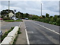
Road (A394) at the Coach & Horses at Kenneggy Downs
Looking eastward.
Image: © Peter Wood
Taken: 30 Apr 2017
0.02 miles
4
Cornwall : The A394
Looking along the A394 as it passes through Cornwall.
Image: © Lewis Clarke
Taken: 16 Jul 2015
0.03 miles
5
The Coach and Horses Inn
The Coach and Horses Inn on the A394 at Kenneggy Downs.
Image: © Elizabeth Scott
Taken: 23 Jul 2011
0.03 miles
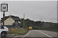
6
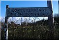
Old Direction Sign - Signpost by the A394, Kenneggy Downs
No finial - 1 arm; by the A394, in parish of Breage (Kerrier District), Lower Kenneggy turn, in hedge.
Damaged Jun 2011 on Streetview, so possibly lost, or buried in hedge.
To be surveyed
Milestone Society National ID: CW_SW5729.
Image: © Milestone Society
Taken: Unknown
0.04 miles
8
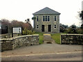
Kenneggy Methodist Chapel
Still in use as a chapel.
Image: © Sheila Russell
Taken: 24 May 2006
0.06 miles
9
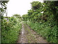
Bridleway to Greenberry Downs
Greenberry Downs is a former mining area.
Image: © Sheila Russell
Taken: 24 May 2006
0.07 miles
10
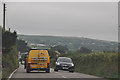
Cornwall : The A394
Looking along the A394 as it heads through Cornwall.
Image: © Lewis Clarke
Taken: 16 Jul 2015
0.08 miles