IMAGES TAKEN NEAR TO
Crowlas, PENZANCE, TR20 8AA
Introduction
This page details the photographs taken nearby to TR20 8AA by members of the Geograph project.
The Geograph project started in 2005 with the aim of publishing, organising and preserving representative images for every square kilometre of Great Britain, Ireland and the Isle of Man.

There are currently over 7.5m images from over14,400 individuals and you can help contribute to the project by visiting https://www.geograph.org.uk
Image Map (Loading...)


Getting Data...Please wait
Leaflet Map data © OpenStreetMap
Images are licensed for reuse under creativecommons.org/licenses/by-sa/2.0
Notes
- Clicking on the map will re-center to the selected point.
- The higher the marker number, the further away the image location is from the centre of the postcode.
Image Listing (16 Images Found)
Images are licensed for reuse under creativecommons.org/licenses/by-sa/2.0
Image
Details
Distance
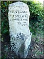
3
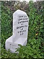
Old Milestone by the A30, south of Crowlas
Carved stone post by the A30, in parish of LUDGVAN (PENWITH District), Ludgavan Leaze, West of Crowlas; West End Marazion, view of St Michael's Mount, in the hedge, on South side of road. Hayle facets, erected by the Hayle Bridge Causeway turnpike trust in the 19th century.
Inscription reads:-
: PENZANCE / 3 MILES / LAND'S END / 13 : : HAYLE / 5 MILES / CAMBORNE / 11 / REDRUTH / 17 / TRURO / 23 :
Carved benchmark on left face.
Grade II Listed. List Entry Number: 1327658
https://historicengland.org.uk/listing/the-list/list-entry/1327658
Milestone Society National ID: CW_PZCA03.
Image: © Ian Thompson
Taken: 10 Dec 2017
0.03 miles
4
Old Milestone by the A30, south of Crowlas
Carved stone post by the A30, in parish of LUDGVAN (PENWITH District), Ludgvan Leaze, West of Crowlas; West End of Marazion, view of St Michael's Mount, in the hedge, on South side of road. Hayle facets, erected by the Hayle Bridge Causeway turnpike trust in the 19th century.
Inscription reads:-
: PENZANCE / 3 MILES / LAND'S END / 13 : : HAYLE / 5 MILES / CAMBORNE / 11 / REDRUTH / 17 / TRURO / 23 :
Carved benchmark on the right of left face.
Grade II listed.
List Entry Number: 1327658 https://historicengland.org.uk/listing/the-list/list-entry/1327658
Milestone Society National ID: CW_PZCA03.
Image: © Rosy Hanns
Taken: 4 Jul 2019
0.04 miles
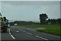
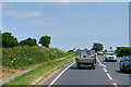
7
Approaching Junction With A30 Near Varfell Cornwall
Image: © Roy Hughes
Taken: 8 Sep 2016
0.09 miles
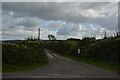
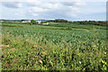
8
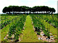
Trees and crops near Ludgvan Leaze
I have no idea what is growing here, in this field near Ludgvan Leaze, but I thought it made a good photograph !
Image: © Mari Buckley
Taken: 19 Apr 2007
0.11 miles
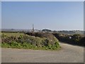
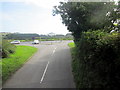
9
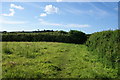
Footpath reaching a corner of a field
St Michael's Way emerges through a stile in the corner onto the A30. The field is occupied by cows.
Image: © Bill Boaden
Taken: 5 Jul 2014
0.13 miles