IMAGES TAKEN NEAR TO
Boscaswell Downs, PENZANCE, TR19 7DT
Introduction
This page details the photographs taken nearby to Boscaswell Downs, TR19 7DT by members of the Geograph project.
The Geograph project started in 2005 with the aim of publishing, organising and preserving representative images for every square kilometre of Great Britain, Ireland and the Isle of Man.

There are currently over 7.5m images from over14,400 individuals and you can help contribute to the project by visiting https://www.geograph.org.uk
Image Map
Images are licensed for reuse under creativecommons.org/licenses/by-sa/2.0
Notes
- Clicking on the map will re-center to the selected point.
- The higher the marker number, the further away the image location is from the centre of the postcode.
Image Listing (18 Images Found)
Images are licensed for reuse under creativecommons.org/licenses/by-sa/2.0
Image
Details
Distance
1
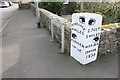
Milestone Pendeen
This large stone dated 1836 is incorporated into the wall of some cottages and it shows the directions for Penzance, St Just, Pendeen, Morvah and Zennor. It is located at the crossroads of the B3306 and the B3318 at Higher Boscaswell.
Image: © Nigel Mykura
Taken: 30 Oct 2017
0.06 miles
2
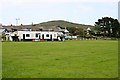
Pendeen Rovers Football Club
The hill in the background beyond the village is Carn Eanes.
Image: © Tony Atkin
Taken: 4 Jul 2007
0.06 miles
3
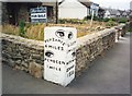
Old Guide Stone by the B3306, Pendeen
Stone fingerpost by the B3306, in parish of St Just (Penwith District), Portherras, Pendeen, 15m North East of Chy Lowena Cottage, at the corner of the boundary wall.
Inscription reads:-
: {pointing hand} / PENZANCE / 6 MILES / {pointing hand} / PENDEEN / 1 MILE : : {pointing hand} / St JUST / 3 MILES / {pointing hand} / MORVAH / ZENNOR / 1830 :
Grade II listed. List Entry Number: 1405974
https://historicengland.org.uk/listing/the-list/list-entry/1405974
Surveyed
Milestone Society National ID: CW_PDSJ01.
Image: © Milestone Society
Taken: Unknown
0.07 miles
4
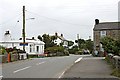
Portherras
This is the eastern end of the extended village collectively known as Pendeen. Brown tourist signs are pointing out the road down past the white house which leads to Pendeen Watch lighthouse.
Image: © Tony Atkin
Taken: 4 Jul 2007
0.07 miles
5
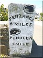
Old Milestone by the B3306 in Portherras
Carved stone fingerpost by the B3306, in parish of St Just (Penwith District), Portherras, Pendeen, 15m Northeast of Chy-Lowena Cottage, at end of a wall.
Inscription reads:-
: {<-hand} / PENZANCE / 6 MILES / {hand->} / PENDEEN / 1 MILE : : {hand->} / ST JUST / 3 MILES / {<-hand} / MORVAH / ZENNOR / 1836 :
Grade II listed.
List Entry Number: 1405974 https://historicengland.org.uk/listing/the-list/list-entry/1405974
Surveyed
Milestone Society National ID: CW_PDSJ01.
Image: © Rosy Hanns
Taken: 4 Jul 2019
0.07 miles
6
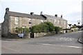
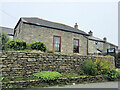
Cottages, Pendeen
These granite built terraced houses are located close to the junction of the B3306 and the B3318 in Higher Boscaswell.
Image: © Nigel Mykura
Taken: 30 Oct 2017
0.07 miles
9
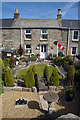
Tin Miner's Cottage, Pendeen
An ex-miner's cottage close to the Geevor tin mine (who is also a railway fan).
Image: © Peter Skynner
Taken: 26 May 2007
0.11 miles