IMAGES TAKEN NEAR TO
Tresaddern Hill, REDRUTH, TR16 5JS
Introduction
This page details the photographs taken nearby to Tresaddern Hill, TR16 5JS by members of the Geograph project.
The Geograph project started in 2005 with the aim of publishing, organising and preserving representative images for every square kilometre of Great Britain, Ireland and the Isle of Man.

There are currently over 7.5m images from over14,400 individuals and you can help contribute to the project by visiting https://www.geograph.org.uk
Image Map (Loading...)


Getting Data...Please wait
Leaflet Map data © OpenStreetMap
Images are licensed for reuse under creativecommons.org/licenses/by-sa/2.0
Notes
- Clicking on the map will re-center to the selected point.
- The higher the marker number, the further away the image location is from the centre of the postcode.
Image Listing (5 Images Found)
Images are licensed for reuse under creativecommons.org/licenses/by-sa/2.0
Image
Details
Distance
1
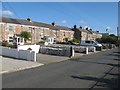
Albion Row, Fore Street
Another fine terrace of stone-built cottages, this time with commodious space which was presumably a kitchen garden originally. The old railway line runs on the opposite side of the row.
Image: © Jonathan Wilkins
Taken: 20 Sep 2019
0.22 miles
2
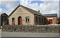
Mills Hall, Carharrack
This is the home of the Carharrack and St Day Silver Band. One thing that links the mining districts of Cornwall and those of northern England is the tradition of local silver (brass) bands.
Image: © Tony Atkin
Taken: 1 Apr 2006
0.22 miles
3
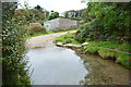
Ford at Little Carharrack
This ford is found just off the main road at Little Carharrack.
Image: © John Walton
Taken: 23 Sep 2015
0.22 miles
4
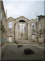
St Day old church - interior
This must truly have been a very impressive church in its heyday.
Image: © Rod Allday
Taken: 15 Apr 2008
0.24 miles
5
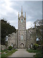
St Day old church
St Day nowadays is a pretty run-down village but the splendour of this (now derelict) church gives an indication of the town's great importance and wealth as a mining centre in the 18th & 19th centuries.
Image: © Rod Allday
Taken: 15 Apr 2008
0.25 miles