
IMAGES TAKEN NEAR TO
Scorrier, REDRUTH, TR16 5AU
Introduction
This page details the photographs taken nearby to TR16 5AU by members of the Geograph project.
The Geograph project started in 2005 with the aim of publishing, organising and preserving representative images for every square kilometre of Great Britain, Ireland and the Isle of Man.

There are currently over 7.5m images from over14,400 individuals and you can help contribute to the project by visiting https://www.geograph.org.uk
Image Map
Images are licensed for reuse under creativecommons.org/licenses/by-sa/2.0
Notes
- Clicking on the map will re-center to the selected point.
- The higher the marker number, the further away the image location is from the centre of the postcode.
Image Listing (14 Images Found)
Images are licensed for reuse under creativecommons.org/licenses/by-sa/2.0
Image
Details
Distance
1
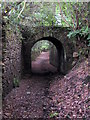
Bridge over public footpath at Scorrier
The bridge was constructed to carry the mineral tramway which ran from Portreath to Devoran.
Image: © Rod Allday
Taken: 9 Jul 2010
0.17 miles
2
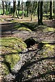
Woodland culvert near Scorrier
This culvert under a track through the woods near Scorrier, just off the B3298, appears to have been made using a recycled section of Victorian cast-iron pipe from the pumping rising main of an old engine shaft.
Image: © John Gibson
Taken: 17 Mar 2009
0.18 miles
3
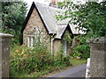
Lodge to Tregullow
Lodge at the entrance of the drive to Tregullow.
Image: © Sheila Russell
Taken: 6 Aug 2005
0.18 miles
4
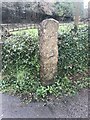
Old Boundary Marker near Tregullow
Mine Boundary Marker beside the drive to Tregullow. St Day parish. This stone defined the mineral rights of local landowners.
Milestone Society National ID: CW_STDCHA18em
Image: © P Barnett
Taken: 9 Feb 2024
0.18 miles
5
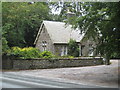
Lodge to Scorrier House
Situated on the St Day to Scorrier road.
Image: © Rod Allday
Taken: 9 Jul 2010
0.19 miles
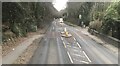
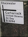
8
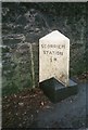
Old Milestone by the B3298, south east of Scorrier
Carved stone post by the B3298, in parish of ST DAY (KERRIER District), Scorrier, North of Scorrier House entrance gate, against estate wall, on West side of road. Erected by the Local Highways Board in the 19th century.
Inscription reads:-
: SCORRIER / STATION / ½ M : : PENRYN / 8 M :
Carved benchmark on right face.
Grade II Listed.
List Entry Number: 1142547 https://historicengland.org.uk/listing/the-list/list-entry/1142547
Milestone Society National ID: CW_PRSS08.
Image: © Ian Thompson
Taken: 10 Dec 2017
0.19 miles
9
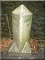
Old Milestone by the B3298, south east of Scorrier
Carved stone post by the B3298, in parish of ST DAY (KERRIER District), Scorrier, North of Scorrier House entrance gate, against estate wall, on West side of road. Erected by the Local Highways Board in the 19th century.
Inscription reads:-
: SCORRIER / STATION / ½ M : : PENRYN / 8 M :
Carved benchmark on right face.
Grade II listed.
List Entry Number: 1142547 https://historicengland.org.uk/listing/the-list/list-entry/1142547
Milestone Society National ID: CW_PRSS08.
Image: © Rosy Hanns
Taken: 4 May 2019
0.19 miles
10
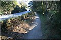
Line of old tramway near Scorrier
Although it looks like a sunken pathway lying beside the B3298, this is the former trackbed of the Portreath Tramway, which now forms a section of the mineral tramways trail that links up with the line of the old Redruth and Chasewater Railway.
Image: © John Gibson
Taken: 17 Mar 2009
0.20 miles