IMAGES TAKEN NEAR TO
Brea, CAMBORNE, TR14 9BN
Introduction
This page details the photographs taken nearby to TR14 9BN by members of the Geograph project.
The Geograph project started in 2005 with the aim of publishing, organising and preserving representative images for every square kilometre of Great Britain, Ireland and the Isle of Man.

There are currently over 7.5m images from over14,400 individuals and you can help contribute to the project by visiting https://www.geograph.org.uk
Image Map
Images are licensed for reuse under creativecommons.org/licenses/by-sa/2.0
Notes
- Clicking on the map will re-center to the selected point.
- The higher the marker number, the further away the image location is from the centre of the postcode.
Image Listing (45 Images Found)
Images are licensed for reuse under creativecommons.org/licenses/by-sa/2.0
Image
Details
Distance
1
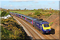
Railway at Brea
Cornish Main Line at Brae.
Image: © Wayland Smith
Taken: 2 Oct 2012
0.05 miles
2
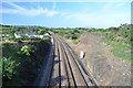
Railway to Penzance
A view of the Penzance line as seen from a small footbridge in Redruth.
Image: © Ashley Dace
Taken: 4 Sep 2012
0.06 miles

4
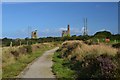
Flat Lode Tail
This path leads to New Cook's engine houses. There are many former tramways in the area and the paths usually follow them.
Image: © Ashley Dace
Taken: 4 Sep 2012
0.07 miles
5

Railway to London
The GWR mainline, Penzance is behind me. The line is an important passenger route.
Image: © Ashley Dace
Taken: 4 Sep 2012
0.08 miles
7
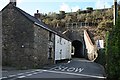
Brea Tunnel
A narrow single-track road tunnel goes through the railway embankment over the Red River valley.
Image: © Tony Atkin
Taken: 3 Mar 2007
0.10 miles
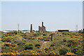
8

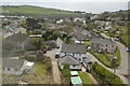
South Crofty
Disused mine near Carn Brae.
Image: © Wayland Smith
Taken: 12 May 2012
0.10 miles
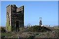
9
Cook's Kitchen Mine
There are two engine houses that served Chappel's Shaft. The visible one is the pumping engine house with a detached stack that has lost its brick upper section. This housed a 50 inch engine in 1838 that was recylinderd to 55 inch in 1872. Behind this is the house for the 26 inch whim dating from about 1860 and this retains a chimney with a brick section.
The mine was named after a miner (Cook) who discovered a copper lode as wide as his kitchen. The mine initially mined copper and later tin.
Image: © Chris Allen
Taken: 28 Apr 2011
0.10 miles
10
Old and New Cook's Kitchen Shafts
The derelict engine house in the foreground is part of the old Cook's Kitchen Mine while the modern winding gear in the background is the headframe over the New Cook's Kitchen Shaft which was sunk in 1907. This was the main shaft for South Crofty Mine until it closed in 1998.
Image: © Tony Atkin
Taken: 3 Mar 2007
0.10 miles