IMAGES TAKEN NEAR TO
St. Georges Road, TRURO, TR1 3NR
Introduction
This page details the photographs taken nearby to St. Georges Road, TR1 3NR by members of the Geograph project.
The Geograph project started in 2005 with the aim of publishing, organising and preserving representative images for every square kilometre of Great Britain, Ireland and the Isle of Man.

There are currently over 7.5m images from over14,400 individuals and you can help contribute to the project by visiting https://www.geograph.org.uk
Image Map
Images are licensed for reuse under creativecommons.org/licenses/by-sa/2.0
Notes
- Clicking on the map will re-center to the selected point.
- The higher the marker number, the further away the image location is from the centre of the postcode.
Image Listing (179 Images Found)
Images are licensed for reuse under creativecommons.org/licenses/by-sa/2.0
Image
Details
Distance
2
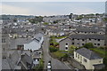
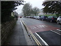
End of George Street, Truro
Towards the railway viaduct.
Image: © JThomas
Taken: 6 Nov 2014
0.01 miles
3
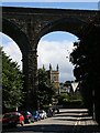
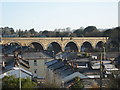
Kenwyn Viaduct
This is one of the two high railway viaducts which cross the City of Truro. The church seen through the arches is St George's in the next grid square to the south.
Image: © Tony Atkin
Taken: 23 Jul 2006
0.02 miles
4
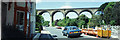
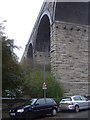
Viaduct over St George's Road, Truro
The viaduct actually stands in the grid square to the north, but the foreground and photographer are in this square, looking northward. The right edge panoramically overlaps my photo of the facade of the former Truro Methodist Church St Georges. In-camera panorama. Photographer at SW821449.
Image: © Elaine Hamby
Taken: Unknown
0.02 miles
5
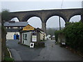
St George's Road, Truro
Looking north west under the viaduct.
Image: © JThomas
Taken: 6 Nov 2014
0.02 miles
6
Railway Viaduct, Truro
The viaduct was designed by Isambard Kingdom Brunel and was originally built on stone piers but with spans of timber fans. It is one mile east of Truro railway station. It is 92 feet high, 1,329 feet long on 20 piers. It was replaced by a new stone viaduct on 14 February 1904.
Image: © Richard Rogerson
Taken: 12 Apr 2009
0.03 miles
8
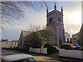
St. George the Martyr, on St George's Road
Image: © Paul Barnett
Taken: 23 Feb 2015
0.03 miles
10
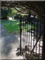
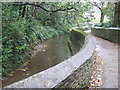
Waterfall Gardens, Truro
A small area of park beside the River Kenwyn, between St George's Road (in the background) and the steep Victoria Gardens.
Image: © Derek Harper
Taken: 6 Sep 2007
0.03 miles