IMAGES TAKEN NEAR TO
Wheal Vor, HELSTON, TR13 9NH
Introduction
This page details the photographs taken nearby to Wheal Vor, TR13 9NH by members of the Geograph project.
The Geograph project started in 2005 with the aim of publishing, organising and preserving representative images for every square kilometre of Great Britain, Ireland and the Isle of Man.

There are currently over 7.5m images from over14,400 individuals and you can help contribute to the project by visiting https://www.geograph.org.uk
Image Map
Images are licensed for reuse under creativecommons.org/licenses/by-sa/2.0
Notes
- Clicking on the map will re-center to the selected point.
- The higher the marker number, the further away the image location is from the centre of the postcode.
Image Listing (7 Images Found)
Images are licensed for reuse under creativecommons.org/licenses/by-sa/2.0
Image
Details
Distance
1
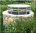
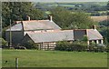
Shaft at Wheal Metal
A sturdy shaft collar & what appears to be a 'bat castle' on a long-disused shaft. Whether or not it's used by bats I don't know, as it was completely flooded when I visited.
Image: © Malcolm Kewn
Taken: 5 Jul 2006
0.14 miles
2
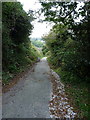
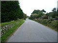
End of the road
This narrow lane leads east out of Trew, accessing the old mine workings on Carnmeal Downs, and gives out onto a footpath shortly beyond this point.
Image: © Richard Law
Taken: 11 Oct 2015
0.14 miles
4
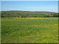
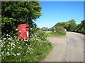
Field of buttercups at Wheal Vor
Tregonning Hill is in the distance.
Image: © Rod Allday
Taken: 3 Jun 2013
0.19 miles
6
A stretch of road at Carleen
A short length of the unclassified lane that joins the B3302 near Sithney Image to the B3280 at Townshend Image
Image: © Richard Law
Taken: 11 Oct 2015
0.23 miles