IMAGES TAKEN NEAR TO
Wendron, HELSTON, TR13 0HR
Introduction
This page details the photographs taken nearby to TR13 0HR by members of the Geograph project.
The Geograph project started in 2005 with the aim of publishing, organising and preserving representative images for every square kilometre of Great Britain, Ireland and the Isle of Man.

There are currently over 7.5m images from over14,400 individuals and you can help contribute to the project by visiting https://www.geograph.org.uk
Image Map
Images are licensed for reuse under creativecommons.org/licenses/by-sa/2.0
Notes
- Clicking on the map will re-center to the selected point.
- The higher the marker number, the further away the image location is from the centre of the postcode.
Image Listing (9 Images Found)
Images are licensed for reuse under creativecommons.org/licenses/by-sa/2.0
Image
Details
Distance
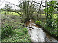
1
River Cober - upstream
Little more than a stream here. The river flows south past Helston and into The Loe.
Image: © Jonathan Billinger
Taken: 5 Mar 2008
0.10 miles
2
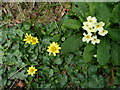
Harbingers of spring
Lesser Celandine (Ranunculus ficaria) and Primrose (Primula vulgaris).
Image: © Jonathan Billinger
Taken: 5 Mar 2008
0.12 miles
3
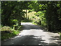
Porkellis Bridge
Crossing the River Cober.
Image: © Rod Allday
Taken: 2 Aug 2008
0.14 miles
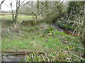
4
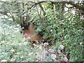
Stream at Porkellis Bridge
The stream flows down to the marshy land of Porkerris Moor.
Image: © Sheila Russell
Taken: 28 Jun 2006
0.19 miles
5
River Cober - downstream
View south from Porkellis Bridge.
Image: © Jonathan Billinger
Taken: 5 Mar 2008
0.19 miles
6
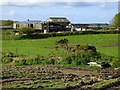
Pasture and farm buildings, Wendron
Wheal Enys Farm at Porkellis viewed from the footpath to Higher Boswin.
Image: © Andrew Smith
Taken: 11 May 2019
0.20 miles