IMAGES TAKEN NEAR TO
Mitchell Hill, TRURO, TR1 1JF
Introduction
This page details the photographs taken nearby to Mitchell Hill, TR1 1JF by members of the Geograph project.
The Geograph project started in 2005 with the aim of publishing, organising and preserving representative images for every square kilometre of Great Britain, Ireland and the Isle of Man.

There are currently over 7.5m images from over14,400 individuals and you can help contribute to the project by visiting https://www.geograph.org.uk
Image Map
Images are licensed for reuse under creativecommons.org/licenses/by-sa/2.0
Notes
- Clicking on the map will re-center to the selected point.
- The higher the marker number, the further away the image location is from the centre of the postcode.
Image Listing (130 Images Found)
Images are licensed for reuse under creativecommons.org/licenses/by-sa/2.0
Image
Details
Distance
1
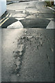
Speed hump, Campfield Hill
Note the damage to the tarmac and imagine the damage done to the cars... this speed hump is too high. I have entered it under "traffic calming measures" but it does nothing to calm the drivers.
Image: © Camilla Comeau
Taken: 17 Dec 2006
0.10 miles
2
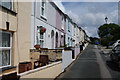
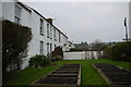
Paul's Row, Truro
A terraced row on a hillside above the city centre.
Image: © Bill Boaden
Taken: 28 Jun 2014
0.10 miles
3
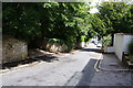
Agar Road, Truro
A residential road made quieter by being blocked off at the bottom.
Image: © Bill Boaden
Taken: 28 Jun 2014
0.11 miles
5
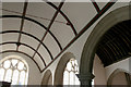
Barrel roof, south aisle of St Paul's Church Truro
This church is sadly now closed as it is in a dangerous condition.
Image: © Camilla Comeau
Taken: 27 Apr 2006
0.13 miles
6
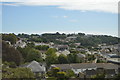
The former Convent of the Epiphany (1910) now Alverton Manor Hotel
Image: © Paul Barnett
Taken: 1 Jan 2017
0.13 miles
7
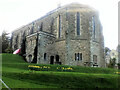
St Paul's Church, Truro
It is Grade II listed but was made redundant in 2007. It is on the market seeking uses that will retain the building as a community asset.
Image: © Bill Boaden
Taken: 28 Jun 2014
0.13 miles
8
Rosewin Hill
Rosewin Hill is a pedestrian snicket, gulley , ginnel , alleyway or footpath that runs from St Clement St north to Rosewin Row which is a row of terraced cottages. On the right of this image is Lower Rosewin Row another similar row of terraced cottages halfway up the hill
Image: © Nigel Mykura
Taken: 27 Feb 2016
0.13 miles
9
Lower Rosewin Row
A row of terraced cottages hidden among the backstreets of Truro with no direct road access, only by footpaths. The access path runs between the cottages and the gardens which have their own access gates.
Image: © Nigel Mykura
Taken: 27 Feb 2016
0.13 miles
10
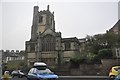
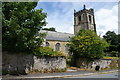
Truro : St Paul's Church
St Paul's Church in Truro on Tregolls Road.
Image: © Lewis Clarke
Taken: 23 Feb 2012
0.13 miles