IMAGES TAKEN NEAR TO
Diptford, TOTNES, TQ9 7ND
Introduction
This page details the photographs taken nearby to TQ9 7ND by members of the Geograph project.
The Geograph project started in 2005 with the aim of publishing, organising and preserving representative images for every square kilometre of Great Britain, Ireland and the Isle of Man.

There are currently over 7.5m images from over14,400 individuals and you can help contribute to the project by visiting https://www.geograph.org.uk
Image Map
Images are licensed for reuse under creativecommons.org/licenses/by-sa/2.0
Notes
- Clicking on the map will re-center to the selected point.
- The higher the marker number, the further away the image location is from the centre of the postcode.
Image Listing (21 Images Found)
Images are licensed for reuse under creativecommons.org/licenses/by-sa/2.0
Image
Details
Distance
1
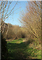
Path near Higher Beenleigh
Harberton footpath 17, seen from the gate shown in Image
Image: © Derek Harper
Taken: 26 Feb 2019
0.05 miles
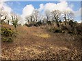
2
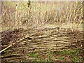
Laid hedge, Higher Beenleigh
This hazel hedge sprouting catkins is alongside Harberton Footpath 17.
Image: © Derek Harper
Taken: 26 Feb 2014
0.06 miles
3
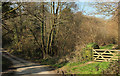
Footpath and lane, Higher Beenleigh
The gate on the right leads onto Harberton footpath 17, which follows the valley of a tributary of the Beenleigh Brook.
Image: © Derek Harper
Taken: 26 Feb 2019
0.06 miles
4
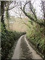
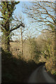
Lane to Higher Beenleigh
Dropping from West Leigh into the valley of a tributary of the Beenleigh Brook.
Image: © Derek Harper
Taken: 26 Feb 2014
0.09 miles
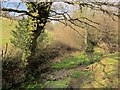
5
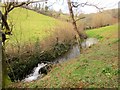
Stream south of Larcombe
The stream shown at Image] drops over a little fall, which serves to pond up its course a little. It forms the parish boundary between Diptford (left) and Harberton.
Image: © Derek Harper
Taken: 26 Feb 2014
0.10 miles
6
Lane to Higher Beenleigh Bridge
From beside the track shown in Image
Image: © Derek Harper
Taken: 26 Feb 2019
0.12 miles
7
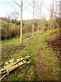
Path to Larcombe Quarries
Harberton Footpath 17 runs between trees and past piles of log and branches. On the left is the stream shown in Image
Image: © Derek Harper
Taken: 26 Feb 2014
0.13 miles
8
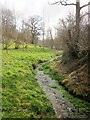
Stream south of Larcombe
Looking down the stream shown in Image], Image and Image], and which forms the parish boundary between Diptford (right) and Harberton. Harberton Footpath 17 runs along on the left.
Image: © Derek Harper
Taken: 26 Feb 2014
0.14 miles
9
Hillside, West Leigh
From the same spot as Image], looking to the right, with some barns on the crest of the valley side.
Image: © Derek Harper
Taken: 26 Feb 2014
0.14 miles
10
Stream south of Larcombe
Looking up the stream that Image] looks down, with a waterside home for some creature that look as if it needs some restoration. The stream forms the parish boundary between Diptford (left) and Harberton.
Image: © Derek Harper
Taken: 26 Feb 2014
0.14 miles