IMAGES TAKEN NEAR TO
Moreleigh, TOTNES, TQ9 7JJ
Introduction
This page details the photographs taken nearby to TQ9 7JJ by members of the Geograph project.
The Geograph project started in 2005 with the aim of publishing, organising and preserving representative images for every square kilometre of Great Britain, Ireland and the Isle of Man.

There are currently over 7.5m images from over14,400 individuals and you can help contribute to the project by visiting https://www.geograph.org.uk
Image Map
Images are licensed for reuse under creativecommons.org/licenses/by-sa/2.0
Notes
- Clicking on the map will re-center to the selected point.
- The higher the marker number, the further away the image location is from the centre of the postcode.
Image Listing (16 Images Found)
Images are licensed for reuse under creativecommons.org/licenses/by-sa/2.0
Image
Details
Distance
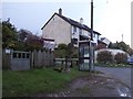
1
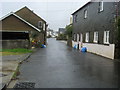
Main road through Moreleigh
Main road through Moreleigh passing footpath to the left and The New Inn to the right
Image: © Shaun Ferguson
Taken: 29 Jul 2009
0.01 miles
2
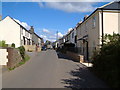
Moreleigh
Looking east along the village street from the western end of the main part of the village.
Image: © Derek Harper
Taken: 24 Aug 2006
0.01 miles
5
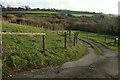
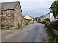
Track, Moreleigh
Leading to a private parking area. In the background is an area of wood and scrub at the head of a shallow valley.
Image: © Derek Harper
Taken: 21 Jan 2023
0.04 miles
6
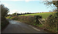
Lane at Moreleigh
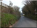
Leaving the main part of the village on its way to Place Barton, where the church is.
Image: © Derek Harper
Taken: 21 Jan 2023
0.05 miles
7
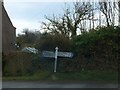
Signpost in Moreleigh
The post is named Diptford Turn on the upright. The picture is taken from the road to Diptford
Image: © David Smith
Taken: 29 Mar 2014
0.08 miles
8
South of Moreleigh
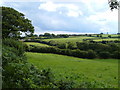
The area immediately south of Moreleigh - actually looking across the line of view in Image- from a little further westward along the lane towards the church. The sewage works is even more discreetly hidden by trees.
Image: © Derek Harper
Taken: 24 Aug 2006
0.08 miles
9
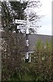
Old Direction Sign - Signpost by Diptford Road, Moreleigh
Annulus finial - 4 arms; Totnes RDC halo by the UC road, in parish of Halwell and Moreleigh (South Hams District), Moreleigh village, Diptford Road, in hedge.
Surveyed.
Milestone Society National ID: DV_SX7652
Image: © Alan Rosevear
Taken: 22 Feb 2013
0.11 miles