IMAGES TAKEN NEAR TO
Wotton Way, TOTNES, TQ9 6DF
Introduction
This page details the photographs taken nearby to Wotton Way, TQ9 6DF by members of the Geograph project.
The Geograph project started in 2005 with the aim of publishing, organising and preserving representative images for every square kilometre of Great Britain, Ireland and the Isle of Man.

There are currently over 7.5m images from over14,400 individuals and you can help contribute to the project by visiting https://www.geograph.org.uk
Image Map (Loading...)


Getting Data...Please wait
Leaflet Map data © OpenStreetMap
Images are licensed for reuse under creativecommons.org/licenses/by-sa/2.0
Notes
- Clicking on the map will re-center to the selected point.
- The higher the marker number, the further away the image location is from the centre of the postcode.
Image Listing (29 Images Found)
Images are licensed for reuse under creativecommons.org/licenses/by-sa/2.0
Image
Details
Distance
1
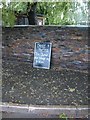
Beer and hymns
That's the spirit. It has rained cats and dogs for three hours, but this sign at a street corner in Broadhempston has been well-protected by an overhanging willow.
Image: © Derek Harper
Taken: 30 May 2008
0.02 miles
3
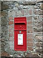
Postbox, Broadhempston
A George VI postbox.
Image: © Maigheach-gheal
Taken: 18 Aug 2008
0.05 miles
4
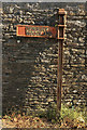
Signpost, Broadhempston
An old sign at the junction of Lower Well with one of the principal lanes through the village.
Image: © Derek Harper
Taken: 22 Oct 2018
0.06 miles
5
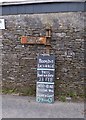
Old Direction Sign - Signpost in Broadhempston
Annulus lost finial - 1 arm (2 missing; 1 in wall opposite); H-section Newton Abbot RDC halo by the UC road, in parish of Broadhempston (Teignbridge District), Lower Well junction with Daniel's Lane, against stone wall of farm (finial lost since Streetview filming).
Surveyed
Milestone Society National ID: DV_SX8066
Image: © Alan Rosevear
Taken: 22 Feb 2013
0.06 miles
6
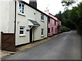
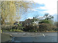
Cottages on the outskirts of Broadhempston
Image: © David Gearing
Taken: 1 Jul 2011
0.07 miles
7
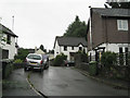
No Place Hill, Broadhempston
A small residential development at the eastern end of the village. I once visited a No Place in County Durham. It was a few streets of terraced houses, former miners' cottages, on a windswept hillside. I'm not sure if this is it Image
Image: © Robin Stott
Taken: 15 Jul 2010
0.07 miles
8
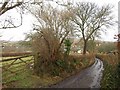
Daniel's Lane, Broadhempston
The back lane also shown in Image, dropping down from Wotten Way past small fields and orchards.
Image: © Derek Harper
Taken: 24 Feb 2010
0.10 miles
9
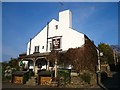
The Coppa Dolla
The unusual name of this 17th century pub means 'coppiced alder tree'.
Today its claim to fame is the 'two-in-one pie' consisting of meat in one half and cauliflower cheese in the other.
Image: © Mark Percy
Taken: 9 Apr 2015
0.10 miles
10
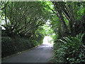
Lane nearing Broadhempston
A short length of lane is overhung by old coppiced hazel. Ivy and ferns predominate in the deep shade.
Image: © Robin Stott
Taken: 15 Jul 2010
0.11 miles