IMAGES TAKEN NEAR TO
South Street, TOTNES, TQ9 5FZ
Introduction
This page details the photographs taken nearby to South Street, TQ9 5FZ by members of the Geograph project.
The Geograph project started in 2005 with the aim of publishing, organising and preserving representative images for every square kilometre of Great Britain, Ireland and the Isle of Man.

There are currently over 7.5m images from over14,400 individuals and you can help contribute to the project by visiting https://www.geograph.org.uk
Image Map
Images are licensed for reuse under creativecommons.org/licenses/by-sa/2.0
Notes
- Clicking on the map will re-center to the selected point.
- The higher the marker number, the further away the image location is from the centre of the postcode.
Image Listing (744 Images Found)
Images are licensed for reuse under creativecommons.org/licenses/by-sa/2.0
Image
Details
Distance
1
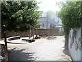
Heath's Garden
A public garden opened in 2010.
Image: © Michael Dibb
Taken: 31 May 2017
0.01 miles
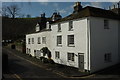
2
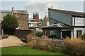
Heath's garden, Totnes
"The garden stands on part of a former commercial market garden, started in 1920 by George Heath senior, and then run by his son, right also George, until 1981" http://totnestrust.org/wp-content/uploads/2016/07/Totnes-garden-Trail-Board_25-May.pdf . The building left of centre, number 10 South Street, was "possibly {a} late C14 defensive tower on the circuit of the town wall, rebuilt following partial demolition during the late C19. Referred to as "the little house on the walls" close by the Shambles Gate in 1462" https://www.historicengland.org.uk/listing/the-list/list-entry/1264388 . Between it and the distinctive modern house on the right is the tower of St Mary's Church http://www.geograph.org.uk/search.php?i=86616184 .
Image: © Derek Harper
Taken: 23 Aug 2018
0.01 miles
3
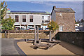
Seating area south of South Street
The sand-covered area has been recently created from a former patch of grass. Large baulks of timber have been placed together to create some kind of seating. The drop from the paved footpath on the left to the sandy area is well over a foot, and being unfenced, I would have thought constituted a safety hazard. The modern building in the background is Totnes Civic Hall. The building has recently been equipped with an array of electricity-generating photovoltaic panels on its roof.
Image: © Richard Dorrell
Taken: 5 Nov 2013
0.01 miles
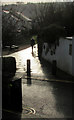
4
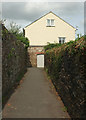
Footpath, Totnes
Leechwell Lane, running between car parks, reaches a cottage where you have the choice of going left through Heath's Garden or right; both routes take you to South Street.
Image: © Derek Harper
Taken: 23 Aug 2018
0.01 miles
5
Former slaughterhouse, Totnes
This row on Leechwell Lane is listed https://historicengland.org.uk/listing/the-list/list-entry/1236466 and https://historicengland.org.uk/listing/the-list/list-entry/1264569 . "Mentioned in 1750 deed as "Dwellinghouse, slaughterhouse, linhay, stables and outhouses". The linhay (combined cattle shelter with haystore over) and outbuildings were converted into cottages circa 1880 (... Nos 3-5 Leechwell Lane).
Image: © Derek Harper
Taken: 25 Feb 2020
0.01 miles
6

Building on South Street, Totnes
"Possibly late C14 defensive tower on the circuit of the town wall, rebuilt following partial demolition during the late C19. Referred to as "the little house on the walls" close by the Shambles Gate in 1462" http://www.geograph.org.uk/search.php?i=86616184 . Below it is the lower arm of South Street; see Image
Image: © Derek Harper
Taken: 23 Aug 2018
0.01 miles
7

Heath's Garden, Totnes
Looking in the opposite direction to Image The path leads left down to Leechwell lane, past an opening into one of the car parks that also doubtless sits on the former market garden's land.
Image: © Derek Harper
Taken: 25 Sep 2019
0.01 miles
8
Entrance to Heath's Garden, Totnes
See also https://www.geograph.org.uk/search.php?i=107286247 . View across South Street. It looks like monochrome, but isn't.
Image: © Derek Harper
Taken: 16 Dec 2019
0.02 miles
9
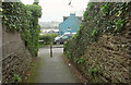
Path, Totnes
The path approaching Leechwell Lane has come from Heath's Garden.
Image: © Derek Harper
Taken: 14 Dec 2021
0.02 miles
10

Totnes from Fishchowter's Lane
A good view of the town centre from Totnes Bridleway 21, with the castle on the left, St Mary's church tower on the right, and the prominent creamery chimney by the railway station. Beyond is a glimpse of the Dart, with the Dartington estate behind on the left.
Image: © Derek Harper
Taken: 8 Oct 2014
0.02 miles