IMAGES TAKEN NEAR TO
TOTNES, TQ9 5ET
Introduction
This page details the photographs taken nearby to TQ9 5ET by members of the Geograph project.
The Geograph project started in 2005 with the aim of publishing, organising and preserving representative images for every square kilometre of Great Britain, Ireland and the Isle of Man.

There are currently over 7.5m images from over14,400 individuals and you can help contribute to the project by visiting https://www.geograph.org.uk
Image Map
Images are licensed for reuse under creativecommons.org/licenses/by-sa/2.0
Notes
- Clicking on the map will re-center to the selected point.
- The higher the marker number, the further away the image location is from the centre of the postcode.
Image Listing (222 Images Found)
Images are licensed for reuse under creativecommons.org/licenses/by-sa/2.0
Image
Details
Distance
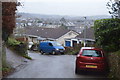
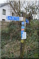
4
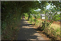
NCN28 approaching Totnes
On the right is new housing built on the former line of Totnes Footpath 2, so I would conclude that this stretch of cycle path also carries the footpath, the John Musgrave Heritage Trail and Dart Valley Trail, which used the old path.
Image: © Derek Harper
Taken: 2 Aug 2019
0.06 miles
6
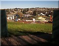
View through the fence, Dart Valley Trail
The fine views over the Dart as one leaves Totnes on the Dart Valley Trail are currently denied by a tall fence above the developments at Baltic Wharf. There is eventually this glimpse where the diverted Totnes Footpath 2 leaves the cycle path. Across the river is Image
Image: © Derek Harper
Taken: 17 Feb 2015
0.07 miles
7
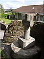
Cross, Totnes Down Hill
A granite cross a little incongruously set between a couple of modern bungalows on Totnes Down Hill, on the southern outskirts of the town close to the beginning of Sharpham Drive. The tower of St Mary's Church is on the left.
Image: © Derek Harper
Taken: 28 May 2007
0.07 miles
10
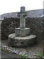
Old Wayside Cross by Totnes Down Hill, Totnes
Cherry Cross, old head and base in a new cross, by the UC road, in parish of Totnes (South Hams District), bottom of Totnes Down Hill, near junction with Moat Hill, in stone wall recess, in front of bungalows.
Surveyed
Milestone Society National ID: DVSH_TOT01
Image: © Alan Rosevear
Taken: 15 Jul 2010
0.07 miles