IMAGES TAKEN NEAR TO
Loddiswell, KINGSBRIDGE, TQ7 4EE
Introduction
This page details the photographs taken nearby to TQ7 4EE by members of the Geograph project.
The Geograph project started in 2005 with the aim of publishing, organising and preserving representative images for every square kilometre of Great Britain, Ireland and the Isle of Man.

There are currently over 7.5m images from over14,400 individuals and you can help contribute to the project by visiting https://www.geograph.org.uk
Image Map (Loading...)


Getting Data...Please wait
Leaflet Map data © OpenStreetMap
Images are licensed for reuse under creativecommons.org/licenses/by-sa/2.0
Notes
- Clicking on the map will re-center to the selected point.
- The higher the marker number, the further away the image location is from the centre of the postcode.
Image Listing (4 Images Found)
Images are licensed for reuse under creativecommons.org/licenses/by-sa/2.0
Image
Details
Distance
1
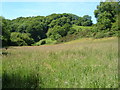
Near Alleron Bridge
Looking along the valley of an unnamed stream (which meets the Avon at Knap Mill) towards Idston Wood. Aveton Gifford bridleway 21 crosses this grassy meadow.
Image: © Derek Harper
Taken: 16 Jun 2006
0.10 miles
2
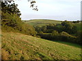
View from Beer Hill
Beer Hill is the name of a byway (behind the hedge on the left) that descends into this valley in the South Hams. The angle of trees on the right marks a sharp bend in Aveton Gifford Bridleway 20a as it climbs towards Lower Heath.
Image: © Derek Harper
Taken: 14 Sep 2006
0.11 miles
3
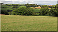
Farmland near Heath Farm
From where Image] was taken, looking more to the left, with Alleron House https://historicengland.org.uk/listing/the-list/list-entry/1306866 right of centre across the valley in Image
Image: © Derek Harper
Taken: 16 Aug 2018
0.19 miles
4
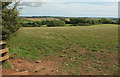
Countryside near Heath Farm
From Aveton Gifford bridleway 20a, looking across the valley of a tributary of the Devon Avon towards the village of Loddiswell.
Image: © Derek Harper
Taken: 16 Aug 2018
0.24 miles