IMAGES TAKEN NEAR TO
Loddiswell, KINGSBRIDGE, TQ7 4DA
Introduction
This page details the photographs taken nearby to TQ7 4DA by members of the Geograph project.
The Geograph project started in 2005 with the aim of publishing, organising and preserving representative images for every square kilometre of Great Britain, Ireland and the Isle of Man.

There are currently over 7.5m images from over14,400 individuals and you can help contribute to the project by visiting https://www.geograph.org.uk
Image Map
Images are licensed for reuse under creativecommons.org/licenses/by-sa/2.0
Notes
- Clicking on the map will re-center to the selected point.
- The higher the marker number, the further away the image location is from the centre of the postcode.
Image Listing (14 Images Found)
Images are licensed for reuse under creativecommons.org/licenses/by-sa/2.0
Image
Details
Distance
1
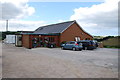
Farm Shop and Cafe
There is a new cafe at this Farm Shop with lovely views up the valley. It is run by the Aune Valley Meat Company.
Image: © jeff collins
Taken: 19 Aug 2013
0.03 miles
2
Footpath by New Bridge
Footpath by New Bridge follows the River Avon south.
Image: © Shaun Ferguson
Taken: 29 Jul 2009
0.11 miles
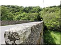
3
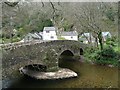
Newmill Bridge
An 18th century Grade II listed bridge across the River Avon near to Loddiswell.
Image: © Robin Drayton
Taken: 30 Apr 2010
0.16 miles
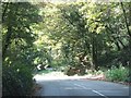
5
New Bridge
The imaginatively entitled New Bridge was presumably built to replace the old bridge just upriver called Newmill Bridge!
Image: © Tony Atkin
Taken: 22 May 2011
0.17 miles
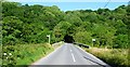
6
Riverside Footpath
The Footpath runs along the Avon from Newmill Bridge crossing the B3196 at New Bridge, it follows the river a little more finally finishing on a minor road near Lower Sturtlebury Wood.
Image: © jeff collins
Taken: 19 Aug 2013
0.20 miles
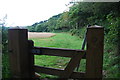
7
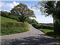
Woodland at the bend in the road west of New Bridge
The road to the bridge turns through 90 degrees just before the crossing; a gate leads straight on into the woodland
Image: © David Smith
Taken: 29 Sep 2011
0.21 miles
8
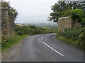
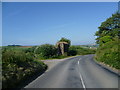
Remains of old railway bridge
The road to Loddiswell passes the remains of the old railway bridge
Image: © Shaun Ferguson
Taken: 29 Jul 2009
0.22 miles
9
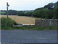
Lane to Rake Corner
The lane down the east side of the Avon from the former Loddiswell station crosses an easting gridline before going out of sight. Taken from the same spot as Image
Image: © Derek Harper
Taken: 3 May 2009
0.22 miles