IMAGES TAKEN NEAR TO
Winslade Close, KINGSBRIDGE, TQ7 2NX
Introduction
This page details the photographs taken nearby to Winslade Close, TQ7 2NX by members of the Geograph project.
The Geograph project started in 2005 with the aim of publishing, organising and preserving representative images for every square kilometre of Great Britain, Ireland and the Isle of Man.

There are currently over 7.5m images from over14,400 individuals and you can help contribute to the project by visiting https://www.geograph.org.uk
Image Map
Images are licensed for reuse under creativecommons.org/licenses/by-sa/2.0
Notes
- Clicking on the map will re-center to the selected point.
- The higher the marker number, the further away the image location is from the centre of the postcode.
Image Listing (49 Images Found)
Images are licensed for reuse under creativecommons.org/licenses/by-sa/2.0
Image
Details
Distance
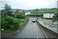
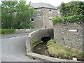
3
Frogmore
Road bridge at the top of Frogmore Creek.
Image: © Jennifer Luther Thomas
Taken: 20 Aug 2006
0.04 miles
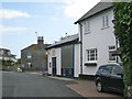
4
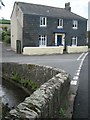
Brook House, Mill lane
A characteristic slate-hung house. Note the vertical stone slabs in the bridge parapet where the brook passes under Old Frogmore Road.
Image: © Robin Stott
Taken: 19 May 2011
0.05 miles
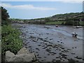
6
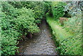
Frogmore stream, east of the bridge at Frogmore
Image: © N Chadwick
Taken: 29 May 2008
0.05 miles
7
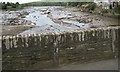
Bridge parapet, Old Frogmore Road
Note the vertical stone slabs to the full height of the parapet, and the massive coping of vertically-set stones. The view is down Frogmore Creek.
Image: © Robin Stott
Taken: 19 May 2011
0.07 miles
8
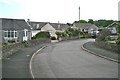
Brook dives under the road
The road in the foreground is Mill Lane, not Orchard Close as shown on Streetmap. The road crossing the brook is believed to be Old Frogmore Road, not Orchard View as shown on Streetmap.
Image: © Robin Stott
Taken: 19 May 2011
0.07 miles
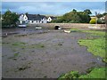
9
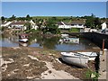
Frogmore Creek
The creek at mid-tide, seen from the head of the slipway. Across the bridge is the A379.
Image: © Derek Harper
Taken: 8 Jun 2008
0.07 miles