IMAGES TAKEN NEAR TO
Goveton, KINGSBRIDGE, TQ7 2DT
Introduction
This page details the photographs taken nearby to TQ7 2DT by members of the Geograph project.
The Geograph project started in 2005 with the aim of publishing, organising and preserving representative images for every square kilometre of Great Britain, Ireland and the Isle of Man.

There are currently over 7.5m images from over14,400 individuals and you can help contribute to the project by visiting https://www.geograph.org.uk
Image Map
Images are licensed for reuse under creativecommons.org/licenses/by-sa/2.0
Notes
- Clicking on the map will re-center to the selected point.
- The higher the marker number, the further away the image location is from the centre of the postcode.
Image Listing (31 Images Found)
Images are licensed for reuse under creativecommons.org/licenses/by-sa/2.0
Image
Details
Distance
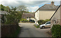
1
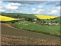
Goveton from near Blackridge Cross
Goveton from Sandy Lane in a network of lanes just East of Kingsbridge in the South Hams
Image: © Nick Cotter
Taken: 30 Apr 2020
0.00 miles
2
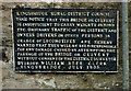
Warning notice, Goveton
A closer view of the notice shown in Image, where the wording is given. It is on the wall of Brook Cottage.
Image: © Derek Harper
Taken: 9 May 2019
0.00 miles
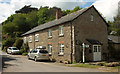
4
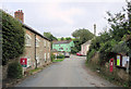
Goveton and K6 phone box
Designed in 1935 by Giles Gilbert Scott the Grade II listed phone box has English Heritage Building ID: 99497.
Image: © Stuart Logan
Taken: 4 Oct 2013
0.01 miles
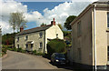
5
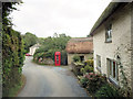
Houses in Goveton
A reverse view of Image Across the junction is Wellcombe https://historicengland.org.uk/listing/the-list/list-entry/1325082 , also shown in Image
Image: © Derek Harper
Taken: 9 May 2019
0.01 miles
6
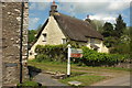
Wellcombe, Goveton
A listed thatched cottage, "C17 or early C18" https://historicengland.org.uk/listing/the-list/list-entry/1325082, in the hamlet. Between it and the signpost runs the brook referred to in the notice shown in Image
Image: © Derek Harper
Taken: 9 May 2019
0.01 miles
7
Cottages, Goveton
The left-hand part is the former village school. https://discovery.nationalarchives.gov.uk/details/r/2e792f50-65cf-4e61-84cc-861565401933 implies that the school was in operation between 1875 and 1926. The signpost and old sign on the wall shown in Image can be seen.
Image: © Derek Harper
Taken: 9 May 2019
0.01 miles
8
Cottages, Goveton
Seen from where Image] was taken, looking right.
Image: © Derek Harper
Taken: 9 May 2019
0.01 miles
9
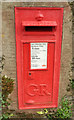
Postbox, Goveton
George V postbox TQ7 16 also appears in Image
Image: © Derek Harper
Taken: 9 May 2019
0.02 miles
10
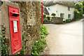
Communications in Goveton
On the left is George V postbox TQ7 16; peeping round the corner is a listed K6 phone box https://historicengland.org.uk/listing/the-list/list-entry/1325081 outside the former post office. Swallows Nest, the thatched cottage in the background, is also listed https://historicengland.org.uk/listing/the-list/list-entry/1108137 .
Image: © Derek Harper
Taken: 9 May 2019
0.02 miles