IMAGES TAKEN NEAR TO
Badgers Green, KINGSBRIDGE, TQ7 1UE
Introduction
This page details the photographs taken nearby to Badgers Green, TQ7 1UE by members of the Geograph project.
The Geograph project started in 2005 with the aim of publishing, organising and preserving representative images for every square kilometre of Great Britain, Ireland and the Isle of Man.

There are currently over 7.5m images from over14,400 individuals and you can help contribute to the project by visiting https://www.geograph.org.uk
Image Map
Images are licensed for reuse under creativecommons.org/licenses/by-sa/2.0
Notes
- Clicking on the map will re-center to the selected point.
- The higher the marker number, the further away the image location is from the centre of the postcode.
Image Listing (176 Images Found)
Images are licensed for reuse under creativecommons.org/licenses/by-sa/2.0
Image
Details
Distance
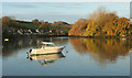
1
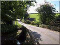
Tacketwood Bridge
The lane from Kingsbridge south towards Collapit crosses a small stream from West Alvington that, immediately below the bridge, forms a side creek of the Kingsbridge estuary.
Image: © Derek Harper
Taken: 1 Oct 2009
0.07 miles
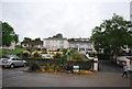
4
Quayside Leisure Centre, Kingsbridge
This large building contains a 25-metre swimming pool, squash courts, fitness studio, bowls hall, sports hall, badminton sourts, dance studio, cafe, and learning resource room, no less. It opened in 1998. Seen from Kingsbridge Footpath 1.
Image: © Derek Harper
Taken: 1 Oct 2009
0.12 miles
5
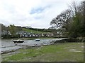
Inlet off Kingsbridge Creek near Tacket Wood
Image: © Robin Drayton
Taken: 25 Apr 2010
0.13 miles
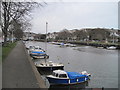
8
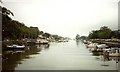
Kingsbridge Estuary
Seen where the inlet below Tacketwood Bridge joins the main estuary, with colourful trees at the confluence. The houses on the left are on a cul-de-sac that seems to be named Tacket Wood, although that doesn't appear on maps.
Image: © Derek Harper
Taken: 13 Nov 2019
0.13 miles
10
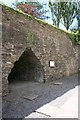
Kingsbridge: old limekiln
Preserved limekiln beside the town’s lower car park. Culm and limestone burnt in the kiln would have been shipped in to the nearby quay in the nineteenth century.
Image: © Martin Bodman
Taken: 3 Jul 2008
0.14 miles