IMAGES TAKEN NEAR TO
Berry Head, BRIXHAM, TQ5 9AP
Introduction
This page details the photographs taken nearby to TQ5 9AP by members of the Geograph project.
The Geograph project started in 2005 with the aim of publishing, organising and preserving representative images for every square kilometre of Great Britain, Ireland and the Isle of Man.

There are currently over 7.5m images from over14,400 individuals and you can help contribute to the project by visiting https://www.geograph.org.uk
Image Map
Images are licensed for reuse under creativecommons.org/licenses/by-sa/2.0
Notes
- Clicking on the map will re-center to the selected point.
- The higher the marker number, the further away the image location is from the centre of the postcode.
Image Listing (89 Images Found)
Images are licensed for reuse under creativecommons.org/licenses/by-sa/2.0
Image
Details
Distance
1
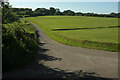
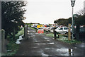
Berry Head Common
From the coast path at the junction of a road (used by footpath BX 4) to Berry Head Farm with Gillard Road (left foreground).
Image: © Derek Harper
Taken: 13 Jun 2021
0.01 miles
2

Berry Head Common
Looking towards the public car park for the headland.
Image: © Jonathan Billinger
Taken: 25 Nov 2010
0.02 miles
3

Signpost on Gillard lane
The South West Coast Path wends its way around Berry Head.
Image: © Neil Owen
Taken: 24 Aug 2021
0.06 miles
4
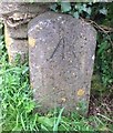
Old Boundary Marker by Berry Head Nature Reserve
Estate Boundary Marker by the UC road, in parish of Brixham (Torbay District), Berry Head Nature reserve, against wall end at T-junction, where Gillard Road bends towards Berry Head Hotel.
Inscription reads:-
^
B O
3
(Board of Ordnance)
Grade II listed.
List Entry Number: 1195201 https://historicengland.org.uk/listing/the-list/list-entry/1195201
Surveyed
Milestone Society National ID: DV_TQKW08aaem
Image: © Milestone Society
Taken: Unknown
0.07 miles
6

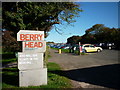
Visiting Berry Head
A car park invites people to explore the important historical, military and natural assets on the headland. It includes a toilet block and information centre.
Image: © Neil Owen
Taken: 24 Aug 2021
0.08 miles
7
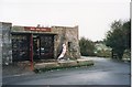
Former Visitor Centre - Berry Head, South Devon
This is the former Visitor Centre for the Berry Head Country Park on the South Devon coast at Brixham. It stands at the south-west end of the Berry Head car park. This car park is, at the time of writing, a pay as you exit car park, although visitors are encouraged to travel by bus and finish their journey on foot. Time photo taken not available.
Image: © Martin Richard Phelan
Taken: 1 Jan 1998
0.08 miles
8
Berry Head car park - Brixham, South Devon
A view, looking northwards, of the Berry Head Car Park near Brixham. Berry Head is the home of a Country Park, Napoleonic War fortifications, a lighthouse and a NATS (National Air Traffic Services) DVOR (Doppler VHF (very high frequency) Omnidirectional Range) radar installation. This photo was taken while at an Easter weekend family reunion of members of the Shropshire Coles and Beaumond families, held at nearby St Mary's Bay Holiday Park. Time taken not available.
Image: © Martin Richard Phelan
Taken: Unknown
0.08 miles
9
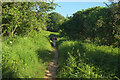
Coast path from Gillard Road
Following footpath BX 7#1 towards Durl Head.
Image: © Derek Harper
Taken: 13 Jun 2021
0.10 miles
10
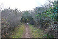
Brixham : Footpath
A footpath heads alongside the coast.
Image: © Lewis Clarke
Taken: 10 Nov 2020
0.10 miles