IMAGES TAKEN NEAR TO
Meadowsweet Lane, PAIGNTON, TQ4 7FL
Introduction
This page details the photographs taken nearby to Meadowsweet Lane, TQ4 7FL by members of the Geograph project.
The Geograph project started in 2005 with the aim of publishing, organising and preserving representative images for every square kilometre of Great Britain, Ireland and the Isle of Man.

There are currently over 7.5m images from over14,400 individuals and you can help contribute to the project by visiting https://www.geograph.org.uk
Image Map
Images are licensed for reuse under creativecommons.org/licenses/by-sa/2.0
Notes
- Clicking on the map will re-center to the selected point.
- The higher the marker number, the further away the image location is from the centre of the postcode.
Image Listing (63 Images Found)
Images are licensed for reuse under creativecommons.org/licenses/by-sa/2.0
Image
Details
Distance
1
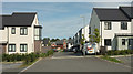
Meadowsweet Lane, Paignton
New houses on the Fusion development near Roselands, most of whose roads are named after wild flowers.
Image: © Derek Harper
Taken: 30 Aug 2018
0.01 miles
2
Houses on Fusion development
The road in the foreground is Wilkins Drive, the main estate road, but I think the address for the terrace in the centre may Meadowsweet Way, although it actually runs parallel to Wilkins Drive.
Image: © Derek Harper
Taken: 30 Aug 2018
0.02 miles
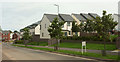
3
Wilkins Drive, Paignton
New housing development off Brixham Road.
Image: © Richard Dorrell
Taken: 15 Sep 2015
0.03 miles
4

Less than generous offer
Bottles don't seem to flying off the shelves as a result of this bargain reduction at Aldi.
Image: © Derek Harper
Taken: 30 Aug 2018
0.03 miles
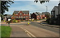
5

Wilkins Drive, Paignton
Approaching the roundabout at the junction with Yannons Road (left) and Parkbay Avenue. In the background is the scene in Image], with a lorry crossing the traffic lights from right to left.
Image: © Derek Harper
Taken: 30 Aug 2018
0.04 miles
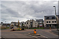
6
Roundabout on Wilkins Drive, Paignton
Part of the Fusion development near Roselands. The road climbing to the right is Parkbay Avenue. Ahead on the left is Wilkins Drive, leading to the A3022, and a sharper left turn is Yannons Road, leading to Aldi.
Image: © Derek Harper
Taken: 30 Aug 2018
0.06 miles
7
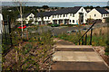
New housing estate, Paignton
Much of this new estate, the Fusion development, has yet to appear on maps, hence the vagueness of the grid references, even though, as you can see, houses are occupied. The steps lead down from a play area to Hollyhock Way.
Image: © Derek Harper
Taken: 30 Aug 2018
0.06 miles
8
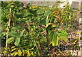
Young hornbeam hedge, Paignton
Much of this new estate, the Fusion development, has yet to appear on maps, hence the vagueness of the grid references. This young hedge is beside steps leading down from a play area and along Hollyhock Way, the adjoining road.
Image: © Derek Harper
Taken: 30 Aug 2018
0.06 miles
9
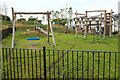
Play area, Fusion development, Paignton
Deserted and possibly inaccessible at the time of capture - I can't remember. On the right is Hollyhock Way.
Image: © Derek Harper
Taken: 30 Aug 2018
0.06 miles
10

Silverweed, Fusion development
I don't recall seeing such a profusion of Potentilla anserina before. This is on a slope beside the play area above Hollyhock Way.
Image: © Derek Harper
Taken: 30 Aug 2018
0.06 miles