IMAGES TAKEN NEAR TO
York Road, PAIGNTON, TQ4 5NS
Introduction
This page details the photographs taken nearby to York Road, TQ4 5NS by members of the Geograph project.
The Geograph project started in 2005 with the aim of publishing, organising and preserving representative images for every square kilometre of Great Britain, Ireland and the Isle of Man.

There are currently over 7.5m images from over14,400 individuals and you can help contribute to the project by visiting https://www.geograph.org.uk
Image Map
Images are licensed for reuse under creativecommons.org/licenses/by-sa/2.0
Notes
- Clicking on the map will re-center to the selected point.
- The higher the marker number, the further away the image location is from the centre of the postcode.
Image Listing (35 Images Found)
Images are licensed for reuse under creativecommons.org/licenses/by-sa/2.0
Image
Details
Distance
1
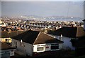
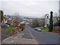
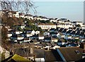
Rooftops in the sun with Torbay in the distance
Rooftops of Paignton with the sea and Torbay in the distance.
Image: © roger geach
Taken: 16 Dec 2009
0.13 miles
2
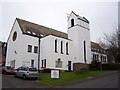
St Michael's Court
Renovated in 1985, this former church and flats behind it are now sheltered homes for the elderly managed by Guinness Care and Support Ltd.
Image: © Richard Dorrell
Taken: 1 Jan 2009
0.13 miles
3
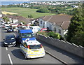
Scene of motor accident, on Penwill Way, Paignton
Image: © Roger Cornfoot
Taken: 21 May 2010
0.14 miles
5
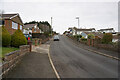
Derrell Road
The 'tree' on the right is actually a telegraph pole, covered in ivy.
Behind it is St Michael's Court - a church converted into sheltered housing for the elderly.
Below that, the trees and shrubs are on the edge of Derrell Road allotments.
Image: © Richard Dorrell
Taken: 1 Jan 2009
0.14 miles
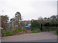
6
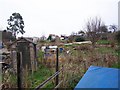
Derrell Road allotments
On the gate to the allotments, the name of the road is mis-spelt 'Derrel'.
Image: © Richard Dorrell
Taken: 1 Jan 2009
0.15 miles
7
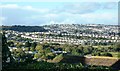
Housing at Penwill Way, Clennon Valley, Paignton
The ribbons of housing development embroider the hills around Torbay. This long string runs along Penwill Way alongside the recreation ground at Torbay Leisure Centre at Clennon Valley.
Image: © Tom Jolliffe
Taken: 29 Oct 2013
0.15 miles
8
Housing at Hayes Gardens area, Paignton
This view was taken from Penwill Road very near to Leyburn Grove. In the far right corner part of the further side of Torbay can be seen in the distance.
Image: © Tom Jolliffe
Taken: 26 Feb 2012
0.16 miles
9
Contrasting entrance gates
The gate on the left is an entrance to the Derrell Road allotments.
The black and gold gates on the right are the entrance to the Kingdom Hall of Jehovah's Witnesses.
Image: © Richard Dorrell
Taken: 1 Jan 2009
0.17 miles