IMAGES TAKEN NEAR TO
Luscombe Lane, PAIGNTON, TQ3 3ZU
Introduction
This page details the photographs taken nearby to Luscombe Lane, TQ3 3ZU by members of the Geograph project.
The Geograph project started in 2005 with the aim of publishing, organising and preserving representative images for every square kilometre of Great Britain, Ireland and the Isle of Man.

There are currently over 7.5m images from over14,400 individuals and you can help contribute to the project by visiting https://www.geograph.org.uk
Image Map
Images are licensed for reuse under creativecommons.org/licenses/by-sa/2.0
Notes
- Clicking on the map will re-center to the selected point.
- The higher the marker number, the further away the image location is from the centre of the postcode.
Image Listing (54 Images Found)
Images are licensed for reuse under creativecommons.org/licenses/by-sa/2.0
Image
Details
Distance
1
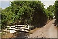
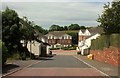
Luscombe Lane
At the junction for King's Aish House and several other properties listed on the fallen gate (left).
Image: © Derek Harper
Taken: 16 Jun 2017
0.08 miles
2
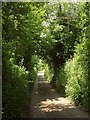
Luscombe Lane
Approaching the turning on the right to King's Aish House.
Image: © Derek Harper
Taken: 16 Jun 2017
0.08 miles
3
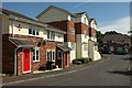
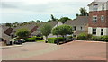
Earlswood Drive, Paignton
Recent housing on an estate bounded by Luscombe Lane.
Image: © Derek Harper
Taken: 16 Jun 2017
0.09 miles
4
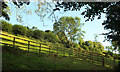
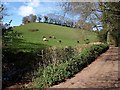
Hillside, Higher Ramshill Lane
Fields below King's Aish House.
Image: © Derek Harper
Taken: 31 Aug 2020
0.10 miles
5
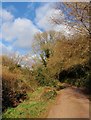
Higher Ramshill Lane
A scene on the lane where it crosses the stream at the foot of the hill shown in Image
Image: © Derek Harper
Taken: 22 Feb 2009
0.11 miles
6
Higher Ramshill Lane
Another view of Image, this time with the lane climbing the bottom of the valley towards Cruel Cross. The small streams running down the main Westerland valley and the side valley on the left meet at lower left of the photo.
Image: © Derek Harper
Taken: 5 Apr 2008
0.11 miles
7
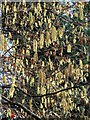
Catkins, Higher Ramshill Lane
Along the stretch of lane shown in Image
Image: © Derek Harper
Taken: 22 Feb 2009
0.12 miles
8
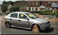
Clamped vehicle, Paignton
Not for a parking infringement but because it's untaxed. One wonders what has taken place for it to be identified. Random police checks?
Image: © Derek Harper
Taken: 16 Jun 2017
0.12 miles
9
Cotehele Drive, Paignton
Cotehele Drive is one of the main routes through this "National Trust" estate. I say "National Trust" because the road names all have some reference to NT properties or people, as far as I can tell.
Image: © Derek Harper
Taken: 16 Jun 2017
0.12 miles
10
Cotehele Drive, Paignton
Seen from the junction with Earlswood Drive.
Image: © Derek Harper
Taken: 16 Jun 2017
0.13 miles