IMAGES TAKEN NEAR TO
Padacre Road, TORQUAY, TQ2 8QQ
Introduction
This page details the photographs taken nearby to Padacre Road, TQ2 8QQ by members of the Geograph project.
The Geograph project started in 2005 with the aim of publishing, organising and preserving representative images for every square kilometre of Great Britain, Ireland and the Isle of Man.

There are currently over 7.5m images from over14,400 individuals and you can help contribute to the project by visiting https://www.geograph.org.uk
Image Map
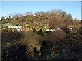
Images are licensed for reuse under creativecommons.org/licenses/by-sa/2.0
Notes
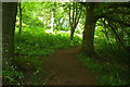
- Clicking on the map will re-center to the selected point.
- The higher the marker number, the further away the image location is from the centre of the postcode.
Image Listing (95 Images Found)
Images are licensed for reuse under creativecommons.org/licenses/by-sa/2.0
Image
Details
Distance
1
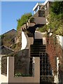
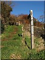
Steps on Padacre Road, Torquay
The price you pay for the best view is a long flight of steps up from the pavement.
Image: © Derek Harper
Taken: 22 Dec 2009
0.02 miles
2
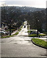
Peasland Road, Torquay
Looking down the road from the T-junction with Padacre Road. The twin churches at St Marychurch in Image break the skyline.
Image: © Derek Harper
Taken: 22 Dec 2009
0.06 miles
3
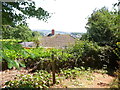
Footpath and road junction, Barton
The footpath leads to Great Hill and forms part of the John Musgrave Heritage Trail (see www.countryside-trust.org.uk/John_Musgrave_Heritage_Trail.htm ).
Image: © Paul Hutchinson
Taken: 24 Nov 2008
0.07 miles
4
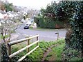
Footpath sign, Watcombe Park
A reverse view of the scene in Image The John Musgrave Heritage Trail makes a sharp turn here at the junction of Seymour Drive with Padacre Road on its way between Brunel Woods and Great Hill.
Image: © Derek Harper
Taken: 22 Dec 2009
0.07 miles
5
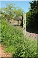
Footpath sign, Watcombe Park
A slight variant on Image, with Seymour Drive in the background. This is the John Musgrave Heritage Trail following an unnumbered path.
Image: © Derek Harper
Taken: 2 Jun 2016
0.07 miles
6
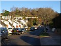
Padacre Road, Watcombe
The upper end of Image, where the road meets Seymour Drive, and there is access to the western end of Brunel Woods.
Image: © Derek Harper
Taken: 7 Feb 2009
0.08 miles
7
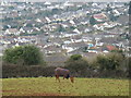
Horse on Great Hill, Torquay
View down over Padacre Road. Great Hill is on the edge of open country.
Image: © David Hawgood
Taken: 14 Feb 2010
0.08 miles
8
Great Hill
At 180 metres, Great Hill is the highest point in the triangle of land between Torquay and the Teign estuary, and has been the subject of bitter wrangles over the siting of telecommunication masts and their height. The current occupant, here largely screened by trees, is shown more clearly in Image
Seen from the path between Brunel Woods and Seymour Drive.
Image: © Derek Harper
Taken: 7 Feb 2009
0.09 miles
9
John Musgrave Heritage Trail approaching Great Hill
Climbing through woodland from Padacre Road.
Image: © Derek Harper
Taken: 2 Jun 2016
0.09 miles