IMAGES TAKEN NEAR TO
Oak View Close, TORQUAY, TQ2 7FF
Introduction
This page details the photographs taken nearby to Oak View Close, TQ2 7FF by members of the Geograph project.
The Geograph project started in 2005 with the aim of publishing, organising and preserving representative images for every square kilometre of Great Britain, Ireland and the Isle of Man.

There are currently over 7.5m images from over14,400 individuals and you can help contribute to the project by visiting https://www.geograph.org.uk
Image Map
Images are licensed for reuse under creativecommons.org/licenses/by-sa/2.0
Notes
- Clicking on the map will re-center to the selected point.
- The higher the marker number, the further away the image location is from the centre of the postcode.
Image Listing (255 Images Found)
Images are licensed for reuse under creativecommons.org/licenses/by-sa/2.0
Image
Details
Distance
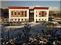
1
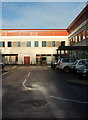
Pomona House, Edginswell Business Park
Housing the South Devon Satellite Renal Unit.
Image: © Derek Harper
Taken: 8 Jan 2016
0.01 miles
2
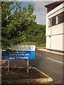
Sign at South Devon Satellite Kidney Unit
On Edginswell Business Park. I shall, rightly, be thought flippant, but I wonder about satellite kidneys and renal parking.
Image: © Derek Harper
Taken: 13 Oct 2013
0.03 miles
3
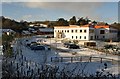
Edginswell Business Park
Seen on a snowy morning, this is the western side of the business park, which has been built in a meadow between the old hamlet of Edginswell (left) and the railway.
Image: © Derek Harper
Taken: 17 Dec 2010
0.04 miles
4
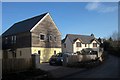
New houses, Edginswell
On the left is one of two new detached houses at Ponds Meadow on Edginswell Lane; next door is the slightly older Oak House.
Image: © Derek Harper
Taken: 9 Jan 2015
0.04 miles
5
Edginswell Business Park
A view of Image from Edginswell Lane. Francis Clark is a firm of chartered accountants who moved into Sigma House in July 2010.
Image: © Derek Harper
Taken: 17 Dec 2010
0.04 miles
6
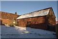
Barn, Edginswell Farm
Apart from the farmhouse itself, no less than eight of the outbuildings Edginswell Farm are listed. This threshing barn, probably early C19, forms the northeast side of the northeast farmyard, and is made of cob on stone rubble http://www.britishlistedbuildings.co.uk/en-390594-threshing-barn-on-north-east-side-of-nor .
Image: © Derek Harper
Taken: 17 Dec 2010
0.05 miles
7
Edginswell Farm
The banner on the barrier is encouraging; Natural Building Solutions are a firm who specialise in the restoration and construction of traditional structures, so the buildings also shown in http://www.geograph.org.uk/gridref/SX8866?centi=SX887661 should receive sympathetic treatment as well as much-needed restoration. Interesting to see how things develop.
Image: © Derek Harper
Taken: 16 Feb 2015
0.05 miles
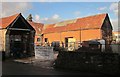
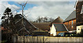
8
![Edginswell Farm [2]](https://s0.geograph.org.uk/geophotos/06/20/14/6201496_d82a0721_120x120.jpg)
Edginswell Farm [2]
This early 19th century threshing barn, a shippon/cider house (at right angles to the threshing barn) and a linhay Image make up the north east farmyard of Edginswell Farm. The two barns have been converted to residential use. Both barns are listed, grade II, with details at: https://historicengland.org.uk/listing/the-list/list-entry/1206767 and https://historicengland.org.uk/listing/the-list/list-entry/1206766
Image: © Michael Dibb
Taken: 30 May 2019
0.05 miles
9
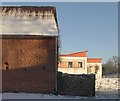
Barn and business unit, Edginswell
Image: © Derek Harper
Taken: 17 Dec 2010
0.05 miles
10
Houses at Edginswell
Beyond the modern houses in the foreground is the now converted farmyard whose buildings appear at http://www.geograph.org.uk/search.php?i=82339597 .
Image: © Derek Harper
Taken: 13 Mar 2018
0.05 miles