IMAGES TAKEN NEAR TO
Seaway Lane, TORQUAY, TQ2 6QF
Introduction
This page details the photographs taken nearby to Seaway Lane, TQ2 6QF by members of the Geograph project.
The Geograph project started in 2005 with the aim of publishing, organising and preserving representative images for every square kilometre of Great Britain, Ireland and the Isle of Man.

There are currently over 7.5m images from over14,400 individuals and you can help contribute to the project by visiting https://www.geograph.org.uk
Image Map
Images are licensed for reuse under creativecommons.org/licenses/by-sa/2.0
Notes
- Clicking on the map will re-center to the selected point.
- The higher the marker number, the further away the image location is from the centre of the postcode.
Image Listing (417 Images Found)
Images are licensed for reuse under creativecommons.org/licenses/by-sa/2.0
Image
Details
Distance
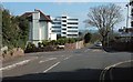
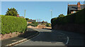
1
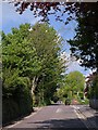
Seaway Lane, Torquay
The road runs up a ridge that reaches the sea at Corbyn's Head and separates the Cockington and Chelston valleys, and travels through very leafy suburbia. Seen here from the crossroads with Hennapyn Road, with the junction with Chelston Road on the right by the postbox.
Image: © Derek Harper
Taken: 12 May 2010
0.02 miles
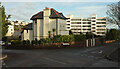
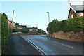
2
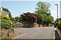
Junction on Seaway Lane, Torquay
With Chelston Road. Down on the right is the crossroads with Hennapyn Road.
Image: © Derek Harper
Taken: 6 Jun 2018
0.02 miles
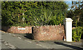
3
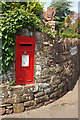
Postbox, Chelston Road, Torquay
At the junction with Seaway Lane shown in Image], this is George V postbox TQ2 20.
Image: © Derek Harper
Taken: 6 Jun 2018
0.03 miles
4
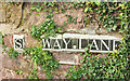
S Way Lane, Torquay
Sad that this tiled road name has been damaged, especially since, unlike most other such tiles across the town which are blue, these are not. Black? Or charcoal grey, perhaps. It should read "Seaway Lane". Also of note is the narrow tile devoted to a full stop, as at https://www.geograph.org.uk/search.php?i=125491301 . Obviously a Chelston thing.
Image: © Derek Harper
Taken: 8 Dec 2020
0.03 miles
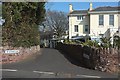
5
Crossroads on Seaway Lane
Hennapyn Lane is the road crossing. Seaway Lane continues ahead down to meet Torbay Road at Corbyn's Head.
Image: © Derek Harper
Taken: 16 Mar 2016
0.03 miles
6
Junction near Torquay station
A slightly different angle on the crossroads shown in Image, with a glimpse of Waldon Hill on the left.
Image: © Derek Harper
Taken: 8 Dec 2020
0.03 miles
7
Junction, Chelston
The diminutive St Agnes Lane turns off Chelston Road.
Image: © Derek Harper
Taken: 25 Feb 2021
0.04 miles
8
St Agnes Lane, Torquay
Seen at its junction with Chelston Road.
Image: © Derek Harper
Taken: 16 Mar 2016
0.04 miles
9
Hennapyn Road, Torquay
Conscious of the fact that Image had been taken without sunlight, I thought I had better provide a sunny alternative.
Image: © Derek Harper
Taken: 25 Feb 2021
0.04 miles
10
Hennapyn Road, Torquay
Approaching the junction with Seaway Lane.
Image: © Derek Harper
Taken: 18 Feb 2021
0.05 miles