IMAGES TAKEN NEAR TO
Drake Avenue, TORQUAY, TQ2 6JN
Introduction
This page details the photographs taken nearby to Drake Avenue, TQ2 6JN by members of the Geograph project.
The Geograph project started in 2005 with the aim of publishing, organising and preserving representative images for every square kilometre of Great Britain, Ireland and the Isle of Man.

There are currently over 7.5m images from over14,400 individuals and you can help contribute to the project by visiting https://www.geograph.org.uk
Image Map (Loading...)


Getting Data...Please wait
Leaflet Map data © OpenStreetMap
Images are licensed for reuse under creativecommons.org/licenses/by-sa/2.0
Notes
- Clicking on the map will re-center to the selected point.
- The higher the marker number, the further away the image location is from the centre of the postcode.
Image Listing (148 Images Found)
Images are licensed for reuse under creativecommons.org/licenses/by-sa/2.0
Image
Details
Distance
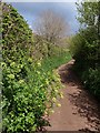
1
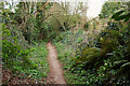
Staddons Lea Lane
Footpath PN 168#1 follows this track from Nut Bush Lane down to Sherwell Valley Road.
Image: © Derek Harper
Taken: 22 Mar 2021
0.03 miles
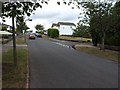
2
Drake Avenue, Shiphay
At the junction with Frobisher Green (left).
Image: © Derek Harper
Taken: 28 Jul 2021
0.04 miles
3
Staddons Lea Lane
Footpath PN 168#1 follows this track between houses on Frobisher Green.
Image: © Derek Harper
Taken: 22 Mar 2021
0.05 miles
4
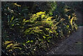
Ferns, Staddons Lea Lane
Male ferns on the bank beside the lane carrying footpath PN 168#1.
Image: © Derek Harper
Taken: 7 Jan 2021
0.05 miles
5
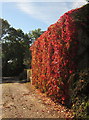
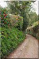
Virginia creeper, Staddons Lea Lane, Torquay
Staddons Lea Lane, an old track carrying footpath PN/168/2 between the housing estates of Chelston, reaches the ridge top at Nut Bush Lane. The line of the track continues down the other side of the ridge as Cockington Lane.
Image: © Derek Harper
Taken: 6 Oct 2012
0.06 miles
7
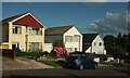
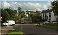
Houses on Drake Avenue, Shiphay
Three detached houses on a hill above the junction with Frobisher Green.
Image: © Derek Harper
Taken: 28 Jul 2021
0.06 miles
8
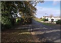
Nut Bush Lane
Nut Bush Lane runs more or less along the city limits of Torquay; at least, along the watershed between the mainly rural Cockington valley on the left (to which Cockington Lane descends here) and the wholly urban Sherwell valley to the right. Permissive paths cross the field on the other side of the junction, where it is unusual to be seen without a dog. The further junction in the photo is where Nut Bush Lane reverts to a country lane (see Image) and the main route turns right into Drake Avenue.
Image: © Derek Harper
Taken: 8 Nov 2007
0.06 miles
9
Upper Cockington Lane
Once one of the few roads in the vicinity, this part of the lane is now reduced to a footpath (TQ 180) running between Drake Avenue and Armada Park recreation ground. https://www.heritagegateway.org.uk/Gateway/Results_Single.aspx?uid=MDV123632&resourceID=104 describes its former significance as a route. Here Alexanders reaches out across the tarmac.
Image: © Derek Harper
Taken: 12 May 2010
0.06 miles
10
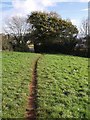
Footpath to Nut Bush Lane
Image: © Derek Harper
Taken: 8 Nov 2007
0.07 miles