IMAGES TAKEN NEAR TO
Rock Road, TORQUAY, TQ2 5SP
Introduction
This page details the photographs taken nearby to Rock Road, TQ2 5SP by members of the Geograph project.
The Geograph project started in 2005 with the aim of publishing, organising and preserving representative images for every square kilometre of Great Britain, Ireland and the Isle of Man.

There are currently over 7.5m images from over14,400 individuals and you can help contribute to the project by visiting https://www.geograph.org.uk
Image Map
Images are licensed for reuse under creativecommons.org/licenses/by-sa/2.0
Notes
- Clicking on the map will re-center to the selected point.
- The higher the marker number, the further away the image location is from the centre of the postcode.
Image Listing (1102 Images Found)
Images are licensed for reuse under creativecommons.org/licenses/by-sa/2.0
Image
Details
Distance
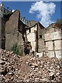
1
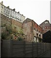
Demolition site, Torquay
Taken 17 months after Image A ruined building, numbers 50-52 Rock Road (above) has been removed, revealing further buildings behind. The site is enclosed by a high fence. Neighbourhood Plan proposals http://torquaynp.org/ currently out for consultation have, as you might expect, highlighted this area for redevelopment.
Image: © Derek Harper
Taken: 6 Dec 2012
0.01 miles
2
Building in Torquay
A building fronting onto Rock Road adjoining the demolition site shown in Image, and seen from Swan Street.
Image: © Derek Harper
Taken: 6 Jul 2011
0.01 miles
3
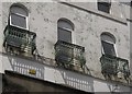
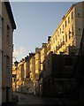
Balconies above Rock Road, Torquay
These are at the rear of houses fronting onto Melville Street. This might be considered one of Torquay's less salubrious residential areas, but these windows must have an excellent view.
Image: © Derek Harper
Taken: 28 Jun 2013
0.01 miles
4
Rock Garden, Swan Street, Torquay
Transformed from Image; the seagull can see outdoor chairs and tables plus greenery behind the fence. The taller building at the rear is the Steamer Quay club and sauna, accessible from Rock Road.
Image: © Derek Harper
Taken: 31 Aug 2018
0.01 miles
5
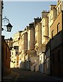
Rock Road, Torquay
In morning sunlight, tall buildings tower above Rock Road as it climbs from Abbey Road.
Image: © Derek Harper
Taken: 26 Nov 2010
0.01 miles
6
Rock Road, Torquay
A similar view to Image The tall houses face Melville Street on the other upper side.
Image: © Derek Harper
Taken: 13 Jan 2015
0.01 miles
7
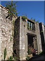
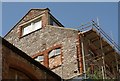
Derelict building, Rock Road, Torquay
What remains of this building (which occupies a large site between Rock Road and Melville Street, above) looks pretty solid. But even the estate agent's notice seems to have given up on it. From a Torbay Council report: "The Methodist Chapel site between Melville Street and Rock Road ... has long been derelict. An imaginative development here, in keeping with the character and local distinctiveness of the conservation area, could be a first step in the badly needed regeneration of the sub-area."
Image: © Derek Harper
Taken: 8 May 2009
0.01 miles
8
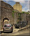
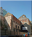
Derelict building, Rock Road, Torquay
See Image and Image Much of the undergrowth (Buddleia, I think) has been cleared, but the ivy continues to spread. A notice attached to the fence refers to this site as a former laundry. The notice calls for expressions of community interest in using this and other sites in Torbay.
Image: © Derek Harper
Taken: 28 Jun 2013
0.01 miles
9
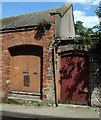
Two doors, Rock Road, Torquay
A pair of wooden doors side by side just up Rock Road from Steamer Quay.
Image: © Derek Harper
Taken: 17 May 2010
0.01 miles
10
Demolition site, Torquay
Adjoining what remains of the old Swan Street (see also Image), and backing onto Rock Road way above.
Image: © Derek Harper
Taken: 6 Jul 2011
0.01 miles